
Summary: 10h total walking (including breaks), from Catchpool to Mt Matthews, out down Mukamuka stream and to Wharekauhau, South Wairarapa. Would likely be a Medium weekend trip or Medium Fit day trip.
Weather: Warm with broken overcast and strong/gale northerlies.
Access: Start at Catchpool road end – we left our car there and retrieved it later. Requires a kind person to collect you in South Wairarapa (google ‘Wharekauhau’ for directions). Suggesting a day in the Wairarapa for them, finishing with a nice dinner in a cafe in Greytown is a great strategy to encourage this.
Phone: spotty reception between south saddle and Mt Matthews. Don’t rely on it, but handy to update your pickup person.
Approximate Timings:
19:30-21:30 (2.0h): Catchpool roadend to Turere Lodge
07:30-09:00 (1.5h): Turere Lodge to start of Mt Matthews track
09:00-10:00 (1.0h): South Saddle junction
10:00-12:00 (2.0h): Mt Matthews return
12:00-15:00 (3.0h): South Saddle Junction to Wharekauhau road end
Total: 9.5h
The Orongorongo valley never ceases to beckon. Its great accessibility, fantastic scenery and interesting terrain is one of Wellington’s greatest and most under-appreciated assets. It’s perfect for spur-of-the-moment tramping, when the weather is clear and you want to get into the hills with a moment’s notice.
I’d read about the Mukamuka Munter in the October WTMC Newsletter, and thought ‘I can do that!’. It all looked pretty straightforward, apart from the need for extreme physical fitness and endurance and mental toughness. I had none of those things, so what to do? A more leisurely approach was c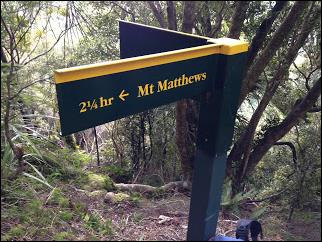 alled for.
To make up for taking the course at a dawdling pace, we thought we should bag Mt Matthews on the way to take in the panoramic views from the top. And there’s always something satisfying about starting in Wellington and finishing in Wairarapa, so we decided as well to come out at Wharekauhau and offer a support-team plan of cafes, shopping and play for the day in the Wairarapa. But the distances looked just a little daunting for a day trip – especially since neither of us had done this trip before. Could we do the whole thing in a day? Maybe, maybe not. We decided to give ourselves a head start, and do some of the easy access walking the night before.
Fri night after work we headed in, stopping b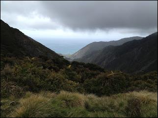 riefly for a fine dining experience at Wainuiomata McDonalds. 7:00pm saw us parking up at Catchpool and leaving the car. When would we see it again? The plan was to retrieve it much, much later. Then we gently wandered in up the Catchpool valley and to Turere Lodge in the gathering dusk. This track can be a bit like Piccadilly Circus during the day, with buggy walkers, hunters, runners and scout groups cheerfully jostling for space. So walking it in peace and quiet with nothing to disturb us but morepork and the occasional call of the kiwi was quite magical.
Our plan was to sleep on the Turere Lodge porch, since it was unbooked but cost prohibitive for just two of us to pay $85 to rent a mattress for 8 hours. When we arrived it turns out a family group had booked at last minute and were well settled in and playing a complex dice game in the lounge. They were cheerfully accepting of two random punters turning up and setting up on the porch. (A side note – that is a smart move on their part! Turere Lodge books up months in advance for Saturday night, but you can book last minute on Friday night and have a quick walk in, a leisurely evening and morning, then a pleasant wander out again.)
We sat out for a while watchi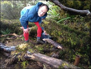 ng the broken cloud scud past at a great rate of knots and throw itself at Mt Matthews. It was calm and pleasant in the valley. But what would the tops be like?
We were up early eating breakfast and running hot coffee through Josh’s magic gold-filter tramping coffee filter. Off the track we set and passed Haurangi Hut after about 20 minutes. This would actually be a better stopping-off point as it’s that little bit closer to your destination – it’s a similar price to book but is similarly new and has a great porch too.
We reached the Whakanui track junction which was our marker to drop onto the river and look for the Mt Matthews track. (Whakanui track would be a good alternative way in – and might be a bit quicker too.)
We rapidly found the Matthews Stream a little upstream. It’s a big braided stream with a big orange triangle marking it. Never saw Baines Hut though, which is allegedly in the bush just at the Matth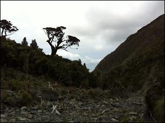 ews Stream mouth. Either it’s been washed away or it’s well hidden. There were enough correlations with the map, though, that we convinced ourselves we were in the right place.
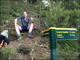
We wandered up the stream bed then followed orange triangles taking us off to the true-left of the stream, across another tributary, and to our first spur. This is where we went from gentle wandering to proper hard work, with a steep scramble for an hour or so. We were relieved to see South Saddle junction sign loom up above us, even though there was no let-up in the slope.
Although we were still very sheltered and the air temperature was quite warm, the wind was starting to pick up through the bush. Here was where we had to make the call whether or not to head up Mt Matthews.
We decided to proceed but constantly reassess how the conditions were. We could always descend again if it was dodgy up top. So we wrapped up warm and dropped our packs at the junction. Eventually the track emerged just above South Saddle, on the ridge we’d follow to the top. The wind was very strong, but it wasn’t too cold, and there were spectacular views into the Wairarapa and the river mouth that would be our destination.
So far so good. We decided to try for the next knoll.
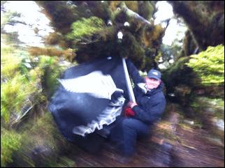
As it turned out the Mt Matthews track is actually very sheltered with battered dwarf beech trees protecting us. It was only the odd time when we emerged briefly into the wind that made us appreciate the degree of shelter we were getting. So we carried on and made the summit after an hour or so.
A slip just before the summit made for quite a bit of scrambling and contorting. An hour’s work with a hatchet or bush saw would make everyone’s lives much easier.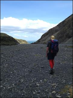
The top of Mt Matthews would be great in fine, still weather but for us we were welcomed with unpleasant gale winds and driving mist. We crouched under the gnarled trees and took ‘been there’ photos. Josh bagged the geocache we found in plain sight at the top. We didn’t hang around.
We rapidly descended to grab a lunch of one square meals, chocolate and carrot sticks at the South Saddle junction. We took advantage of a bar or two of cellphone signal to text out to reassure our pickup party and give them a tighter ETA. Then it was time to hit Mukamuka. But first, we had to cross South Saddle.
South Saddle gave us the worst conditions of the trip. The wind was funnelling through the saddle making it hard to stand. We huddled and shuffled our way across the saddle and dropped into the Mukamuka valley, where the wind rapidly dropped away to nothing.
Various maps have the path down Mukamuka stream as a track, a route, or nothing at all. It’s very much a track. The first part was very clearly marked and recently maintained, with foliage and trees cleared and felled. Eventually the stream began to get quite large, and after a while the markers became fewer and stopped. I guess DOC figure that if your navigation skills don’t let you follow the stream then there is no hope for you! It was quite technical going with sli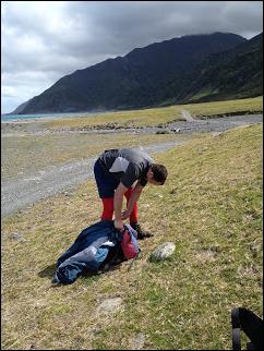 ppery unstable rocks and dead wood making slips and ankle breaks a potential at every step. Don’t know how the Muntees do this competitively at speed. Ligaments of iron, lots of experience and oodles of self-belief I guess.
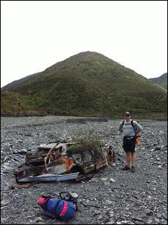
The river became bigger and bigger, and a little more straightforward going. We found ourselves in a fairly gorgy bit, with scouring on the side of the banks showing the river’s power when it was in full flood. Further down, where the river really opened up wide, we found a very sad, crushed and battered Mazda 323. Looks like some enthusiastic locals had driven it up the valley, got it bogged, and then the force of the river had well and truly dealt to it.
The wind slowly rose again as we got closer to the coast, and the funnel effect of the valley began asserting itself. It was fortunate it was a tail wind. Again, I don’t know how the muntees kept their spirits up with an interminable uphill and a strong headwind battering them.
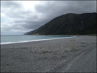
The south coast suddenly came into view, which was a welcome sight. Our hopes that the wind would drop at the coast were for naught; we wrapped up again as wind drove spray and sand into our faces. Job done! We had bagged Mt Matthews and defeated the Mukamuka valley. Now we had the walk out before our mission was completed.
Another option here is to turn right instead of left at the coast, and walk back to the mouth of the Orongorongo, then back to Catchpool, or a car left at the end of the coast road (about 10km drive on from Catchpool). That would make it a there-and-back, but quite a bit longer and with hours of interminable trudging along the coast around Baring Head.
But for us, it took maybe an hour of strolling along the coast road 4wd track, until we met our pickup driving towards us.
 We were prepared to keep walking until we either met our pickup or reached tar-seal. The road gradually changes from gravel road to 4wd track, with two big fords and a gravel fan to cross before your pickup driver reaches Wharekauhau township. The fords were straightforward on our weekend, but whether your driver can make it that far will depend on their confidence and how much the rivers are up.
We had stashed a change of clothes in our pickup car, which gave us a semblance of neatness – enough to get us into a Greytown cafe for craft beer and tapas. I’ve decided that more tramping trips need to end with craft beer and tapas! We made it back to Wellington in plenty of time to get back to our Catchpool car, though our plan was to wander in again the next day to get it back. As we arrived we found the SAR team kitting up and setting out for what we hoped was an exercise but turned out was very much for real (but with a happy ending).
So the Munter is a great trip even if you’re not the sort of person who thinks of running over a mountain in a few hours as a pleasant Saturday morning diversion. It’s eminently do-able as a daytrip, albeit a long one with an early start and the likelihood of needing a head-torch for the last wee bit along the coast road. And there are many variations to make the trip longer or shorter or logistically easier. Who knows, maybe you’ll be inspired to run it, too?