
 Saturday morning saw us heading off up the four wheel drive track leading to Temple Basin in the clag. The morning was misty and cool, with a chilly breeze but we hoped it would clear as the really bad stuff was not supposed to arrive until tonight.
Sure enough, as we gained height the cloud started to disperse and the views opened up around us.
It’s a steep haul up the ski field, at one point there is a line of stakes with a rope strung along between them as an aid to pull yourself up the steep rocky slope, it is the first time I could have used a Jumar device while tramping.
As you approach the top of the final ski tow, the best route is to head slightly left to the low point as this appears to be the actual Col and it is straightforward to cross here on both sides.
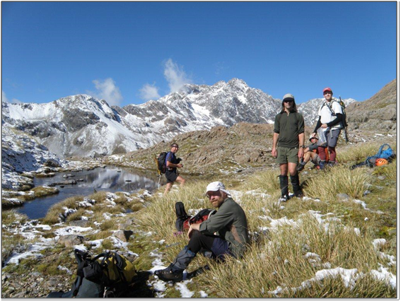 We stopped here for a while, for snacks and to bask in the sun and take in the view.
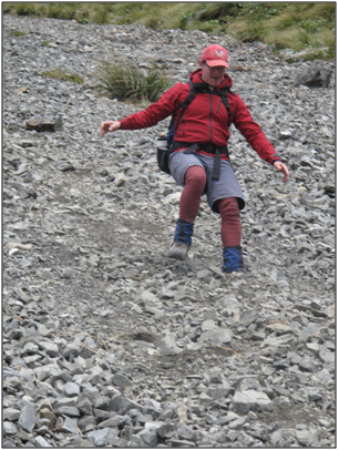
Directly below the col there is a great little shingle slide, so I took off down this at speed, only to realise as I reached the bottom of it that I had left my gloves back at the col.
My pack came off and I had to retrace my steps at a somewhat more leisurely pace back up the hillside to retrieve the missing items. On the plus side I did get two shots at the shingle slide, while the others only had one.
 The route down from here is occasionally cairned and is straightforward with good visibility; you wouldn’t want to get off it though as the drop off on either side is considerable. We had taken our ice axes and crampons as we were lead to believe that there might be snow on the northern slopes of the col. There was not, however, a drop of the white stuff anywhere; so while we might have looked like serious punters, the hardware was to stay attached to the packs.
 Reaching the river we followed it down to where it gorged up and sidled up on the true left as advised. The route here goes a bit pear shaped and we tried both higher and lower versions without any real success. The ground here is scrubby and you are continually dropping in and climbing out of a number of awkward little gullies; I would advise the higher option until able to see a line down to the flats. Then it is 50/50 whether to stay high or drop down to where a trail finally appears again on the flats, both routes join up around the corner as you sidle up the true right of the Mingha to where you can find a crossing point and reach the luxury of the boardwalk up to the Goat Pass.
 While about halfway across the scrubby sidle, I thought I spied a cairn lower down, so I dropped my pack and headed down to check it out, it turned out to be a false lead though and when I returned back up the slope my pack had done a disappearing act. I searched frantically through the snowgrass climbing higher and higher with no success. Finally realising I had climbed higher than my starting point, I stopped and zig zagged back down the slope trying to rediscover my pack, the feeling of panic as you contemplate life in the hills without everything you need to survive is somewhat unique. Fortunately it reappeared, I had left it sitting up, but it had toppled forwards and slid into a hollow underneath a snowgrass bush making it invisible from below. This was the first time I had ever misplaced my pack and as these things usually come in threes I was wondering what I could possibly misplace next!
The others meanwhile were waiting patiently ahead, wondering what on earth I had been up to.
By the time we hit the boardwalk the breeze was picking up and the cloud cover starting to return so we headed to Goat Pass Hut for lunch. Here we got a weather forecast via the hut radio: winds up to severe gale around the tops, a sharp drop in temperature, with rain overnight and rain or hail for Sunday afternoon.
This was enough for us to rethink the high camp at Lake Mavis that night. Instead we left our gear at the hut and headed off up the hill to at least have a look at the lake.
The wind got stronger and stronger as we headed up the hill and the cloud base lowered to start covering the tops again. There is a reasonably sheltered campsite at the head of the lake. Lying on the small grassy flats there the wind was nonexistent, whereas on the route up it was quite strong and very cold. After photos and a look around we headed off back down, this time taking the scree slide back down to the hut, this is recommended if you are up this way. The route up follows up from a cairn just off the track further south and would be the best way to ascend, but the scree slope dropping back down to just along from the hut is fast and fun.
That night we turned to cards, where Sharron and Tom won a game of 500, while Mike won one all by himself, (I was pretty much a partner in name only at that point). Not to be outdone though I called and won a hand which also won the game, those who have played with me will realise the magnitude of this. I probably only bid a handful of times over three games, so this was quite a big deal and cause for some celebration.
The promised rain arrived overnight and the morning was cold, wet and miserable, there was supposed to be a brief clearance before the next cold front swept in though so we hung round trying to come up with a plan that worked. Finally patches of blue sky started to appear so we left around lunchtime to head down the Mingha and out to Arthurs Pass. The forecast for Monday was good so we hoped to achieve something as a day trip then.
As we came out of the bush on to the open riverbed the temperature dropped again and it started to rain, as we progressed downriver we also got the occasional view of the tops above, now freshly coated with snow.
Geoff had been up the Edwards planning to meet us to traverse the Polar Range and he had both hail and snow as he descended the track down from Edwards Hut.
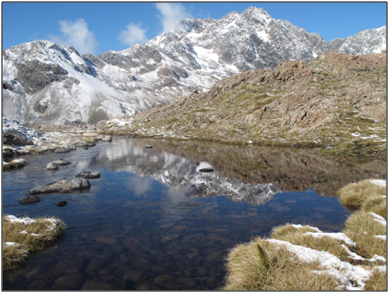
That night Geoff caught up with us and convinced us he had a good route up Mt Philistine that we could all manage. So the next day found us heading up the Otira River, arriving at the footbridge we headed up the hill to where the usual route follows up a steep spur, carrying on past this to the north there is a very nice line that follows various ledges, gullys and stream beds to arrive at the flat spot on the shoulder above where there is a lovely tarn with a magic view. From here we rejoined the usual route up and some 2 ½ hours after leaving the road we were on top. The day by now was gloriously fine and warm with almost no breeze. The snow from the day before had coated most of the surrounding peaks and ridges and was ankle deep on top of Philistine. Even Temple Basin was covered in snow for the first half of the day.
Fantastic views, with Rolleston up close in front of us, the trip up Philistine is highly recommended if you have a spare day down this way.
This was a great finish to the trip and went a long way to easing the disappointment of missing out on the Polar Range.
Thanks again to Sharron for leading and organising us.