
If that was the forecast for Auckland what was the rest of the country going to get that weekend?
I was in now in Plan B mode and instead of packing a sarong, sunblock and fly swat I was packing a down jacket, over trousers, merino jumpers and extra plastic bags for a four day trip along the three year old Hillary Trail, Waitakere Ranges Regional Park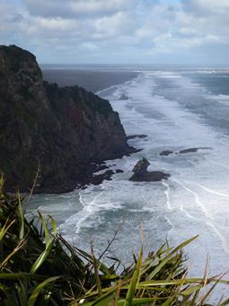 , Auckland. I had been thinking I was going to walk along sub-tropical beaches in warmth, not heading into a South Island storm.
The Auckland Regional Council (ARC) downloadable guide of the four to five day 75km Hillary Trail is full of useful information, tips, and suggestions of where to camp using the ARC campgrounds (and lists private campgrounds and bach accommodation at the end). The four day trail concludes on its final day as a 27km 11-12 hour walk from Craw Campground to Muriwai Beach. This was the seed of the idea of walking the trail as a solo fit trip in 72 hours; winter dawn started at 7am and darkness at 6pm.
I caught the plane from Wellington and was collected by a friend who drove me to lunch at Titirangi and started the trail at 4pm. I traversed the beautiful kauri forests before darkness descended at 6pm near Huia Dam and hence walked along the beach at low tide to the ARC’s Karamatura campground in the dark. (11km, 3 hours).
The second day was a 400m climb over to Whatipu where I watched the antics of the Boy Scouts compete in the strongest man competition and run around orange cones in the mud while carrying heavy packs. I was greeted with a large cup of tea at the shelter (while escaping the gusts of wind at lunchtime) and talked to the ranger and volunteers planting natives.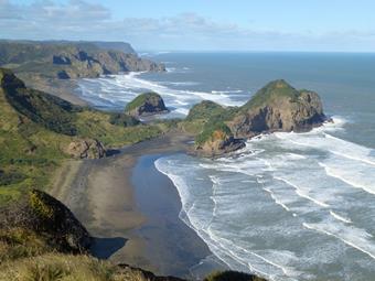
The ranger suggested Tunnel Point was the best for camping as dry and flat, but I did remind him a gale was forecasted for that night and I did not want to be on an exposed beach when it hit land. I continued on to Pararana Campground for the night. One of the luxuries of winter camping is there is no competition for the best camp site (i.e. flat dry level ground, a gurgling stream beside to lull me to sleep and a shelter to cook in). Fully sheltered by flax and totora from the gale that blew through the night, I slept well and woke to a dry, warm tent. (14.5km 8-9 hours including breaks).
Day three was a gem, blue skies, warm winter sun, no wind, big black sand beaches as the tide was out and the place to myself. In summer these beaches would have been crowded. (Not mentioned in the guide is that if you check the tides, one could walk this section of the trail along the beach and not climb the inland track). A lovely long walk on the firm sand to Tunnel Point, and then northwards to Karekara. The recycling truck visits Monday 9.25am. I waved it down to give the driver my book as a donation; I had finished reading it the previous night. Another joy of winter camping is that it is dark at 6pm, bed is at 7pm, books are read and the night sleeping is long.
A second café stop at Karekare and on Sundays there is another café open at Piha. A steady climb up the hill to Crew Campground followed. I still had a couple of hours of daylight so pushed on and wild camped literally on the track at Lake Waibanu, overlooking the still flat lake while listening to the rolling, crashing waves on the beach beyond the sand dunes and spur. It was a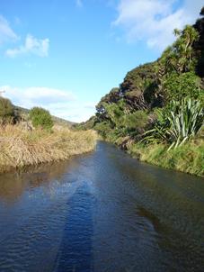 great place to camp as I missed the inland frost and awoke the next morning to another dry tent. (26km, 9.45hours).
The fourth day was another beautiful day and I was in shorts sleeves and thinking my sarong might have been useful. Although the guide is fairly comprehensive, the Park Ranger I met mentioned it was about to be rewritten as there are a few missing hints for this trail. I agree with that statement as urban area trail markers are vague and more of those beloved orange triangle plastic markers would be a welcome addition. This was particularly so on day four when the guide stated “…at this point the Hillary Trail follows Waiti Stream to Bethellls Beach….”, meaning literally that for a couple of kms one walks in the stream from the exit of Lake Wainamu (where the black sand dunes start) to St Bethells Beach, and ignore the four wheel drive track on the adjacent bank which land owners will not let you walk upon.
Although the trail is open all year round, not mentioned in the guide is that DOC land north of Bethells Beach is closed for lambing in August and September.
From St Bethells north the trail is a beautiful sea cliff path, wild, exposed and beautiful as it winds its way around the headlands. Followed by before an hour of grass verge walking before the descent on the attractive Quarry Trail to the albatross colony at Muriwai. Another reason to walk the trail in July is that the albatross are returning to nest. The sunset on the beach was gorgeous. I wild camped along the beach in the dunes. In total a 72 hour walk.
The Hillary Trail would make a great club off-peak season four-day trip, thereby missing the crowds at the beaches and campsites with options for cafe walkers and medium and fit tramps. Enjoy the numerous café stops along the way and accommodation can be in ARC, private campgrounds, wild camp or stay in pre-booked baches.