
We arrived at 2.30pm at Wellington Railway Station, for a 2.45pm get away.
We had a quick gear check and food item sound-off to make sure we had all brought our ingredients for a shared meal on Saturday Night.
Mon kindly picked up the club van, and then us, and off we went to catch the Interislander. It left at 3.45pm, and was on time. Smooth sailing.
We arrived at Picton at around 7.30pm and drove to Kerr Bay (at Lake Rotoiti), arriving at about 9pm, to set up camp for the night. Tents were put up under torch light. A beautiful clear night and a relatively straight forward event. The two Sams shared a tarp. Jane and Noel shared a tent, and the rest of us had our own. We had a quick discussion to make sure we would all be up and away on time in the morning. Sam went through who had the billy/gas/cooker/PLB/first aid kit and fly. The Easy group (of two) were without a cooker, so as our group had a surplus cooker, we were able to leave them with one. Lovely to have an evening cuppa – made easy with the zip in the shelter at the camp site. A wee bit of luxury. We fell asleep under the light patter of rain drops.
The next morning, we woke to a light shower. Enough to make gear damp, but not dampen our spirits. Most of us left our tents in the van. It was nice not to have to put them away in our packs. Being a newbie to the group, I had thought of a few questions as I adjusted to my new tent. The next morning, I approached Sam to speak with him. Dressed in my shorts and t-shirt, feeling gung-ho. Before he even said good morning, he thrust insect repellent at me. This is a must if you are staying at Kerr Bay!!! Thanks for having my back (or should I say skin).
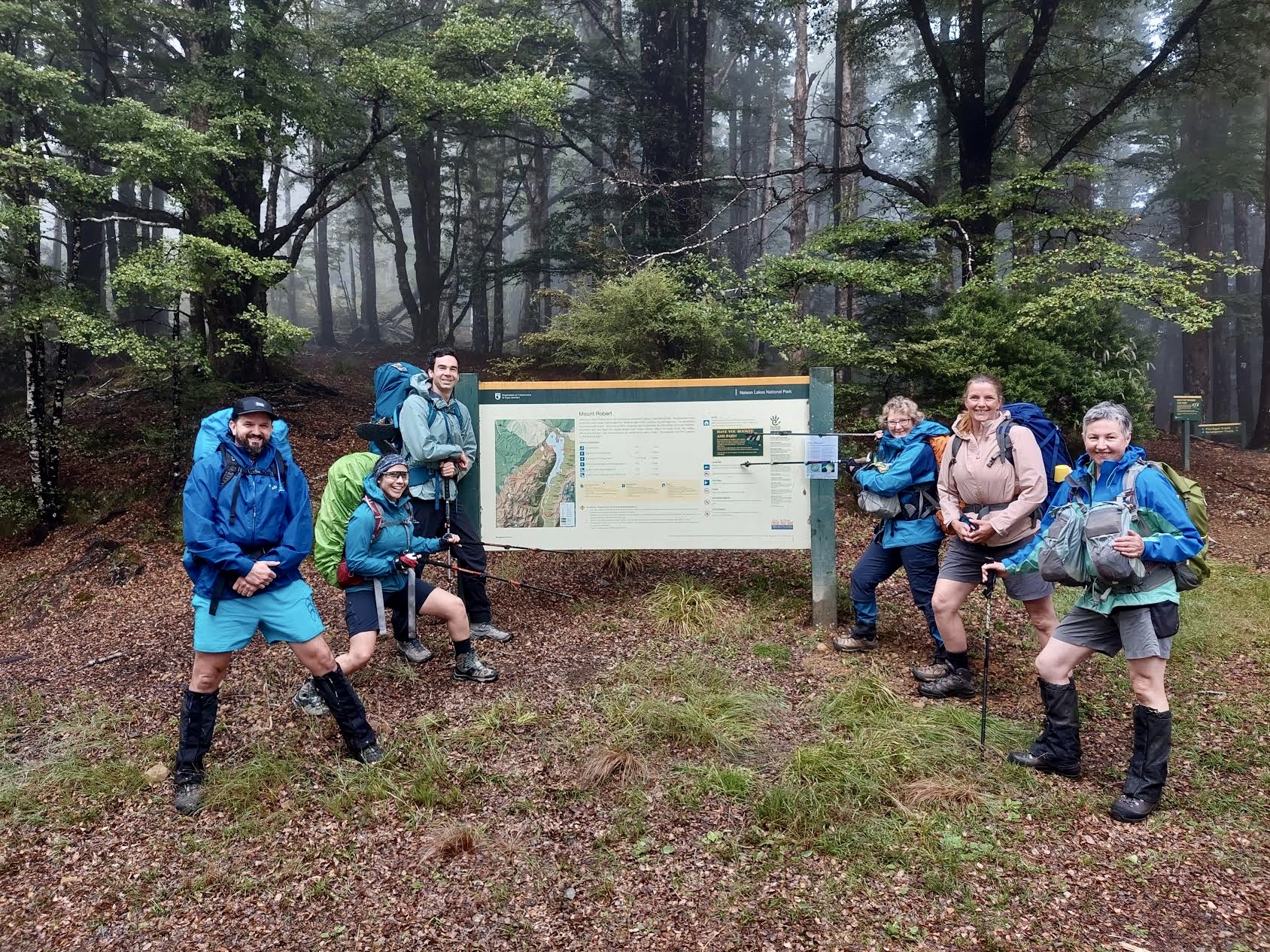
By the time we had packed down and had breakfast the sun was out and we were off. We dropped Karen and Michaela off. Their lakeside walk started about 10 mins down the same road as our walk. We parked at Mt Robert car park. There is a toilet there.
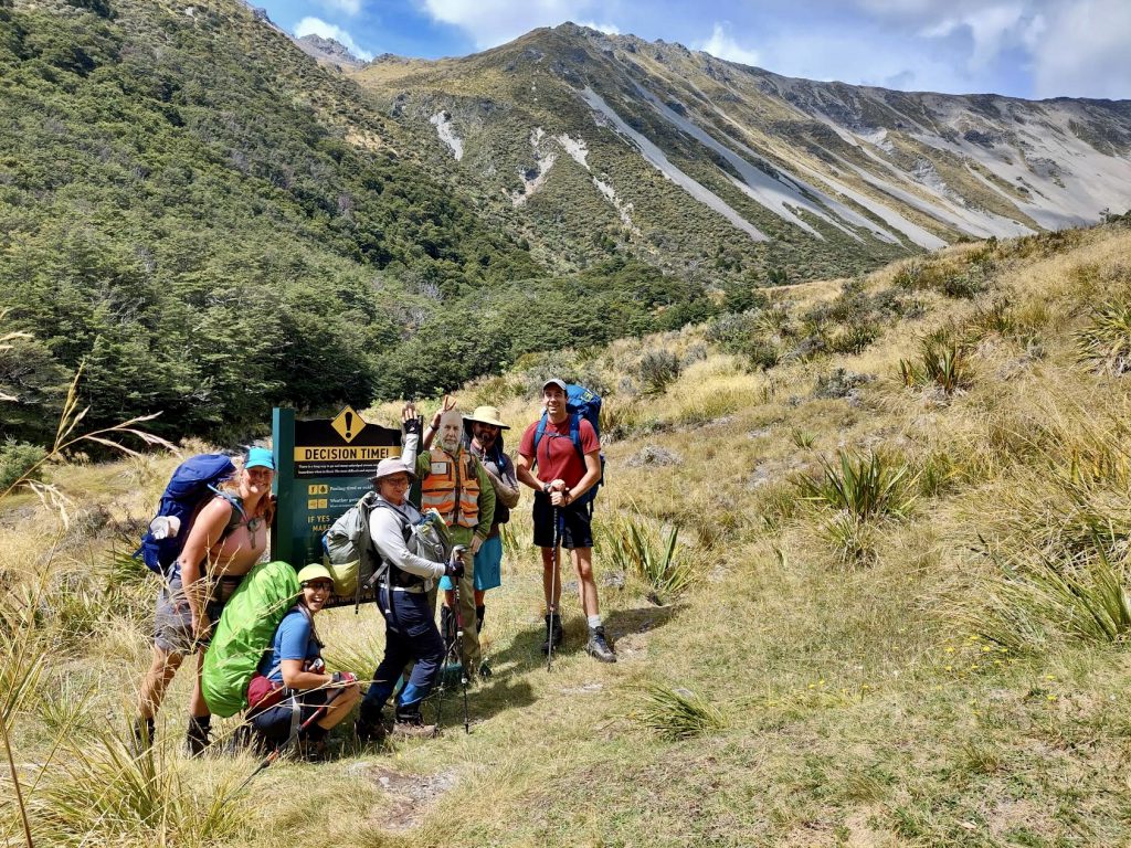
We had a look at the map and expectations of time on the track. We were allowing ourselves about 9 hours to get to Angelus Hut. Potentially, there may be some visibility issues walking up the valley towards the saddle. This route was marked by poles with orange markers – poor visibility might make seeing them difficult.
The first 3 hours of the track was under beautiful beech forest. Underfoot was quite damp and muddy in places. Care was needed as it was quite tree rooty and slippery. I proved this by falling heavily 15 mins from the start. Although I was certain I hadn’t injured myself in any serious way, the resulting haematoma didn’t make itself felt until the next morning. Despite the initial ‘oops!’, we trotted along at a steady pace, stopping for photos and snacks as the group needed, until we reached Speargrass Hut.
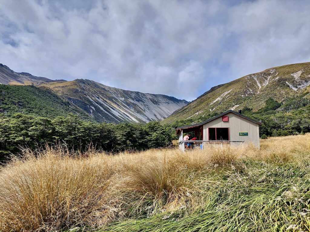
A great place for a spot of lunch. We stopped here for about 45 – 60 mins. A leisurely break, and we enjoyed the sun and a sit down. Sam D had some blisters forming, so minor first aid was done so they didn’t develop any further. Heels covered and sheep wool to reduce friction and we were off to climb a mountain.

Walking up through the valley was quite mind blowing. It started with some forest and simple boulder hopping back and forth across the river. We all noticed quite quickly that we had to be mindful of watching the markers. We briefly lost sight of them, and despite heading in the correct direction, it is good practice to have a scout about. The group stayed put, and the two Sams had a quick search. While they were searching, the group found the marker. A quick blast on the whistle got their attention, and we were able to regroup quickly. All done in a matter of minutes.
Despite having to watch out for markers and our feet (as lots of speargrass meant we couldn’t always see our feet) we left the forest and came out by the river. The plants were quite interesting and we all enjoyed listening to Sam discuss them – he was able to name a good few of them. We started to cross back and forth across the river while the terrain was growing steeper. At one point, Sam D spotted a deer – but I missed it (at least at the time I thought he said he had. I spent about 20 mins watching out for it.) What he actually said, I have no idea. Mon showed us snowberries, and every now and then someone would stop to have a little munch.
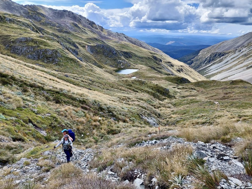
We climbed until the terrain went up another gradient. A track sign stated a further 800m ascent to the top. This is where we decided to have a snack and a sitdown. We replenished our water bottles. Most of us cooled off with a splash to the face – and a head dunk for Sam D! There was a small section here of about 10m of scree-like terrain. I had to find a new gear to get up it. Not difficult, just a change of traction for the feet. Then the slog begins.
Over the next 600m we stretched out a bit – all of us finding our pace to get up the valley. We all were in awe of the steep scree slopes, and the sheer size of them, as they towered around us. The valley was a contrast of green and grey rock – beautiful, awesome and frightening. We all had eyes on the ridge – each of us questioning if that was the Robert ridge track. It looked very narrow, with a massive scree slope to assist your descent, should you slip.

With another 200m climb to go, we stopped for afternoon tea. Just needing that boost to get us up. The weather was bluebird, and it was just amazing to be able to sit there and look back the way we had come, right down the valley. None of the clag we discussed at the start of the day was to be seen.
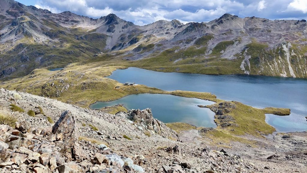
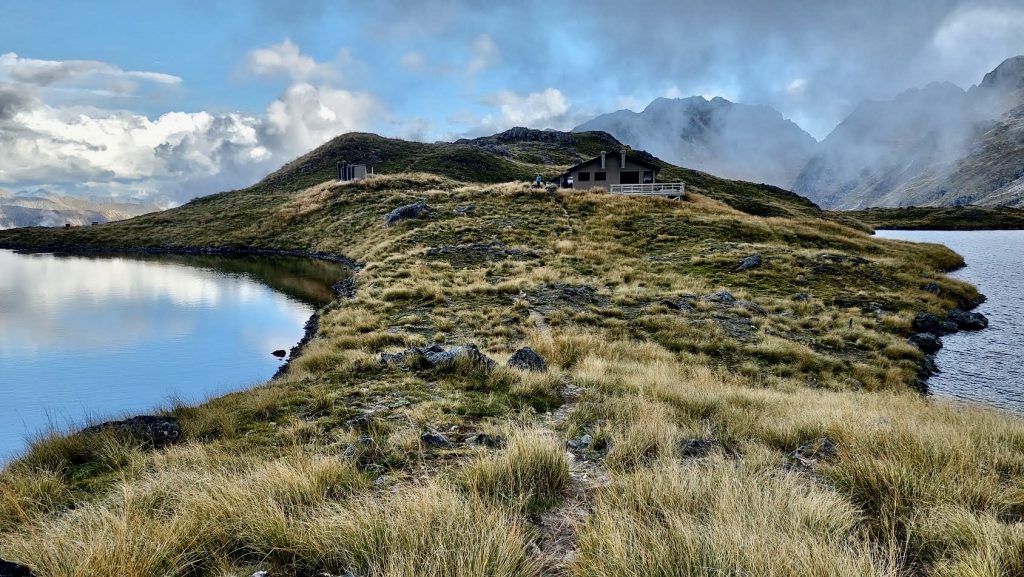
As we reached the top, we came across the sign to Angelus Hut. Only to find out it was 1km down the next valley. Stunning view! It is a steep, rocky climb down, and it took 30mins to reach the bottom. We arrived happy, but tired, 4 hours and 45 minutes after leaving Speargrass Hut.
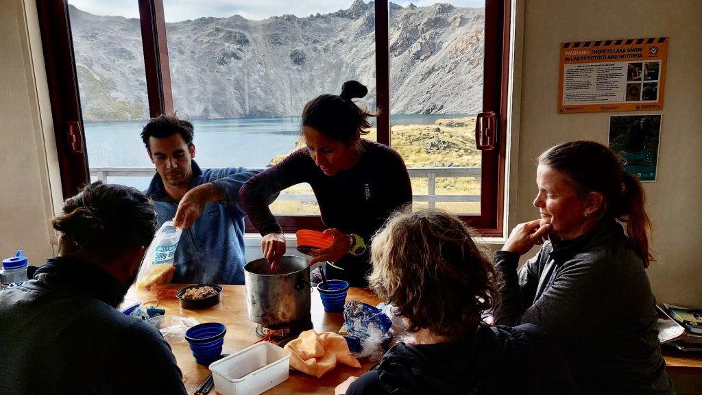
Dinner comprised a mushroom lentil dish out of the WTMC cook book. Very yummy, and enjoyed by all. Not a scrap left. We were all very happy to see that Noel supplied some dark peppermint chocolate for dessert. Also devoured.
The hut was busy, campsites full, but plenty of space for all. As we finished dinner, the clag rolled in, and there was a shower of rain. We listened to the Warden talk, and settled on 9am as the time to leave the next morning (after the 8.45 am weather update).
We all retired to bed early.
Day 2 Angelus Hut down Robert Ridge to Relax shelter and out to Carpark. (6 Hours)
I woke about 12.30am for a rare midnight toilet stop. Very reluctant to get out of my bunk to go. I am so glad I did.
It wasn’t particularly cold, so I was quite comfortable despite being lightly clad. A clear, calm night. The sky a million pin pricks of light, you could not help but stop to take a moment to appreciate it all.
Noisy neighbours woke me at 5.30am and then another group at 6.30am. Quiet was not on their agenda. (Probably my only complaint of the trip). I figured I wasn’t going to go back to sleep, so I got up and put the billy on. Slowly everyone emerged and got ready for the day. A few were ready before 9am and so headed back up the long climb. I got busy exploring around the hut and wandered along the tarns before heading back out. We regrouped at the sign at the top before heading out along the ridge.
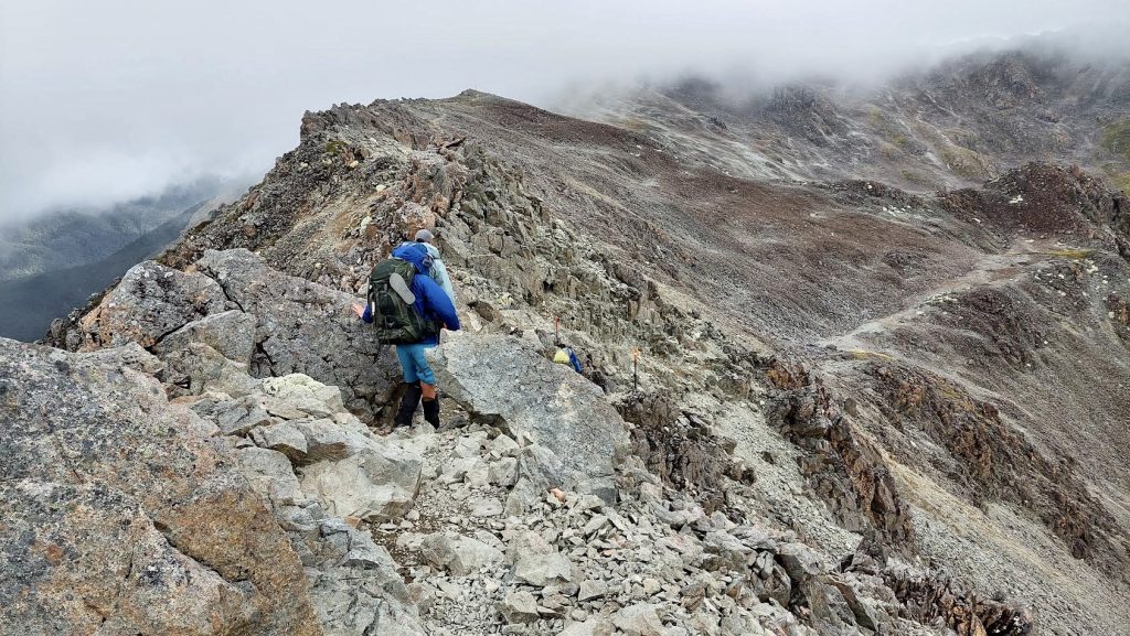
Robert Ridge had looked very daunting the day before. As we approached it, we could see a clear path, albeit along the top of a very steep scree fall.
The weather was cloudy and gusty, with the expectation of up to 50k by the end of day. Although it was blowing, I felt safe climbing along. Mon led with a good steady pace that was very comfortable for me. I thoroughly enjoyed the walk. Challenging in places and unpleasant to find the odd loose rock. After a good solid 2 hours, we dipped in behind a rise that protected us from the wind and enjoyed a good 20 min break – to eat and take photos.
The ridge runs for about 4 kilometers, and requires your attention to find suitable footholds. Most of us were able to chat along the way, but mostly it was single file.
As we started our descent, we met ‘Dave’ – our nickname for DOC’s Poster Boy – who let us know we were leaving a significant mountainous avalanche area.
From there, it was a very pleasant stroll down to the Relax Shelter. We stopped here – I had lunch, but most had a snack and were looking forward to the toastie sandwich shop in Picton. There was some good information to read about the area in the Relax Shelter, and it is worth stopping to have a look.
From the Relax Shelter, it was an hour back to the car (on a well graded track). Plenty of day walkers were walking up. Back at the car, we changed out of our stinky clothes and jumped into the van to go and pick up Michaela and Karen. Total walking time was around 4 hours. 10 mins down the road (which is very bumpy and narrow) I had to ask Mon to turn around. I had left my mobile phone in the loo!!!! The rookie error meant I ended up having to write the trip report 😊.
We met Michaela and Karen back at Kerr Bay campsite – where they had just got out after a swim. 90 mins later, we were back in Picton. The ferry trip was delayed by 2 hours, so we all went our own way for a bit, and then met back at the van for booking in at the ferry.
Lovely weather, fantastic loop walk and an awesome group of people. Highly recommend.
Must bring:
Bug spray! Kerr Bay campsite – lots of sandflies.
Sunscreen – climbing up the valley: hot and no cover. Water is easy to access.
Togs – Kerr Bay (Lake Rotoiti). And if you’re keen, you can swim in the tarn on the left at Angelus Hut.