
For more photos and the entirety of Sharron’s nearly 4000 word expression of love for Tussock can be found on her blog.
Years of tramping, camping and running have given me a deep appreciation for tussocks. Given this minor tussock obsession coupled with my fondness for hills it’s perhaps not surprising that one of my favourite trail running events is the Motatapu Adventure Run.
The first Motatapu was held in March 2005 when the weather around Wanaka is invariably fine and settled something that cannot be said with similar confidence about north island tussock country. Back in 2005 the event consisted of a mountain bike race and a marathon run linking Glendu Bay with Arrowtown via Motatapu Station. 1,000 participants attended the inaugural event. In 2015 when I lined up for my second Adventure Run I was merely one of 4,000 participants signed up for one of five events. In marked contrast to the previous 10 years the early March forecast was not promising delivery of fine, settled weather.
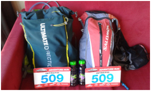
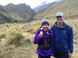
Tim and I had entered the 51km Adventure Run as a team before we had a chance to run together. In our defence we had spent 45 hours propelling each other across the finest tussocks on offer in the Tararuas on an SK mission.
After that experience we knew we shared a sense of humour, determination and the ability to get stuff done. We figured this equalled a tick for the most important team criterion – must still be on speaking terms when race ends. When we finally did go on a few training runs it was obvious we were not well matched in terms of pace. Would this matter? We debated many times the merits of taking advantage of the fact that for the 2015 event it was possible to run the race solo. In the end Tim’s dedication to the team ethos won out. We should have named our team Tussock. Maybe the fact that I’d done the run the previous year would compensate for my lack of pace. Maybe not given my tapering efforts consisted of the Tarawera 100km, a 35km Southern Crossing and the 44km Tongaririo Northern Circuit plus Ngauruhoe.
 Then there was the issue of the weather forecast – heavy rain, snow to low levels and gale force winds. We expected to be on exposed tops for at least 10 hours. Our focus switched to ensuring we had the right gear and a race strategy. As race day drew nearer we scrambled to acquire light weight crampons, the item on the compulsory gear list neither of us owned. Tim bought one of the last pairs of crampons available at Bivouac Wellington. They were a size too small for his trainers but if he didn’t wear them he’d be able to swap them for a pair the correct size when he got back to Wellington and no longer needed them! I bought a more expensive but matching pair in Wanaka after it became clear that for the first time in the race’s history the race organisers were going to require us to carry crampons. I reluctantly conceded the pair I had borrowed expecting to leave in the gear trailer would be too bulky and heavy to run with.
We set off a bit later than scheduled up the four-wheel drive track to Fern Burn car park. Team Intrepid was painfully slow over this section. Poor Tim, he was probably already realising it would be a long day. He soon acquired my expensive, superfluous crampons to add to his own when we decided we may as well use weight redistribution as a method for evening up our respective speeds. From the car park the track meanders for 7km along the true right of the Fern Burn, passing shrub land and grassy flats. It then climbs through remnant beech forest before the valley narrows and you pass a few waterfalls. About thirty minutes in the track skirts a corner of the Stack Conservation Area then continues to the bush edge and on to upland tussock country and the Fern Burn hut (720m).
 This section requires headlamps due to the early start and in this instance the poor visibility even when it did get light. Conditions underfoot were slippery particularly on the descents. I was soon regretting leaving my Salomon Speedcross 3’s with their big lugs in Wellington. They would have been a better option for the conditions than my heavy XA Pro 3s. Tights were a good option though, serving both to keep the mud off and some warmth in our legs. The last big descent before the climb to Fern Burn Hut was particularly treacherous, more like mud skiing or auditioning for an episode of Wipe Out than running. Volunteers yelled encouragement as we slid toward them.
Fern Burn Hut to Highland Creek Hut 6km
Our strategy was simple: just keep moving. In the cool, damp conditions water was not a priority and it was important not to stand around getting cold. From the hut the track descends to the river then continues along the Upper Fern Burn through tussock to reach Jack Halls Saddle at 1275m. For this section we were heading into a southerly which fortunately was considerably lighter than forecast. I put on my windproof gloves to go with my woolly hat. Our raincoats remained in place and conditions remained slippery. Water and mud chilled our feet. Our inability to get a good grip underfoot along with the cold was sapping our energy and morale though we retained enough energy for cursing. Fortunately as we crested the saddle and started traversing the temperature rose slightly allowing us to think about something other than the temperature.
 With spare brain capacity we figured out that running slightly off the formed track afforded better purchase hence greater efficiency. We remembered to eat raising both our spirits and energy levels. From the saddle route descends abruptly to a creek bed, before navigating another two ridges and descending to Highland Creek. We made steady progress through this section, noting with relief that the rain was easing even if visibility remained marginal with big wisps of mist hanging above and below us. Highland Creek hut (850m) is nestled in a spectacular upland basin. We took a moment to enjoy the view and banter with the wonderful volunteers checking off our race numbers then it was back out onto the trail Tim munching on his potato crisps as we went.
Highland Creek to Roses Hut 11km
The section from Highland Creek to Roses Hut is my favourite part of the course. It boasts a couple of big climbs interspersed with a couple of big descents. The up and down is relentless, brutal but strangely rewarding. Always keen to wrangle a bit more pace out of me Tim would point out figures in the distance for me to chase down and I would plod determinedly upwards until we did just that. It worked until I started thinking about what was going to happen once we reached the flat again. After crossing Highland Creek the track sidles and climbs above another unnamed creek onto a prominent spur. In clear weather this section is one of the course highlights affording stunning views across the Motatapu Valley.
Climbing helped heat us up but the temperature was rising anyway. We were able to replace woolly hats with sunhats though we didn’t remove raincoats until Roses Hut. From our prominent spur we continued up before negotiating several steep sidles over drying tussock. This was followed by a descent into a steep gully, where we crossed a creek through remnant beech forest to climb once more onto the leading south-west ridge of Knuckle Peak. Here views of the Motatapu Valley opened up on our right. After skirting round rather than cresting the peak we followed the ridge down to the Motatapu River to join the track used by the mountain bikers and marathoners. Our route heads up the trail towards these competitors. Some marathoners looked confused and advised us we were going the wrong way. One awesome woman yelled out “go adventure girl”. We climbed a fence and headed across some open flats to Roses Hut (681m).
Roses Hut marks the half way point so I stocked up on water, Tim still had plenty. For the first time ever I had decided to rely on the event electrolyte drink. This turned out to be a bad decision as the electrolyte mix was so watered down as to be completely ineffective. There was a nice looking carrot cake but we elected to reduce our weight by eating our peanut butter and jam sandwiches while removing a few layers of clothing as the sun had emerged while snapping a few photos. “Our transitions are more efficient than my running” I reflected as we left the hut still munching our lunch ahead of a couple of teams that arrived before us.
Roses Hut to Macetown 10km
After crossing a small creek we reached an old pack track that climbs to the main ridge near the 1270m Roses Saddle. This track is almost a four-wheel drive initially then narrows to form a zig zagging single track. The climb to just below Roses Saddle is the last major climb so it’s where you find out if you went too hard on the other hills. Our pace remained steady so I think from my perspective at least we did all right. At the crossover point between the Motatapu and Arrow catchments the ridge descends to the Arrow river. Fantastic views in every direction including down to the Arrow catchment. I thoroughly enjoyed the contrast to the mornings’ rain drenched climbing.
 At the Arrow River its decision time. During normal to low river levels it is quicker to head down the river to Macetown rather than take the high track. But it has been raining heavily overnight and in the days prior. Last year I inadvertently took the high route while my team-mate went down the river. This year, we are sticking together. We settle on the river thinking with our tramping experience we will ford it efficiently and make good time finding routes on its banks.
In retrospect I’m not sure we made the right decision though it did provide for some variety as we focused on trying to pick the best line through a cold, fast flowing river. The banks were lined with matagouri which added to the pain factor though it did not take long for us to lose feeling in our feet if not our hands. Occasional swearing ensued whenever one of us made the mistake of reaching out for a hand hold to help us keep our balance in the strong currents. As we made our way downstream the river crossings grew progressively more interesting till we were doing waist deep crossings. I was beginning to get concerned. “This is a bit marginal” I mentioned to Tim who had already fallen in a big hole hidden by matagouri and had blood all over him. A little further on we met a couple of race marshals heading up river. They suggested we head up to the high route for the last section on the basis it is well benched at this point and so probably quicker travel. We had our doubts but the idea of getting warmer was appealing so we decided to head up.
In retrospect it would have been better to stick with the river as we had in fact done the worst of it and we burned energy we didn’t really have bashing our way up to the high route then following its roundabout path all the way to where it drops to the Macetown aid station. I thought fleetingly of my experience on the same section last year in the baking heat with lizards leaping out of my path as I risked crunching them underfoot. No sunbathing lizards today. Meanwhile the teams close behind us stayed in the river and overtook us. Later we found out that race winner Jason Schlarb did the same thing we did which made me feel both slightly better about our choice and even more in awe of his amazing race time.
Macetown to Arrowtown 15km
Once you reach the Macetown aid station all the technical trail is done and you just have to follow a four-wheel drive track that weaves its way through the river. This is the section where you can really put your foot down. Unfortunately my consecutive weekends of long runs had taken their toll as had the cold conditions and my lack of proper fuelling along the way. I was feeling slow and tired. My running was equivalent to Tim’s fast walking. In our haste to forego the chocolate cake on offer at the aid station I also neglected to check my water supply. About 50 meters down the track I discovered I had none. Instead of going back and filling my camalbak with electrolyte I just scoped water out of the river and carried on. The next 9km were painfully slow when they should have been easy travel. Badly fatigued I found I couldn’t eat and my stomach was not happy. Think about something else I thought as I plodded on having insisted that Tim go ahead.
With 6km to go the track again re-joins the course used for the marathon and the mountain bike race. Here I grabbed a cup of correctly mixed electrolyte and some jet planes. This simple sugar hit was enough to get me going again and my pace picked up, I was still fairly slow but going much better than on the previous leg. Tim and I chatted to each other and some of the marathon runners as we made our way through the scenic Arrow gorge anticipating the finish.
About 2km before the finish line where the route normally joins the Arrow River for the final run into Arrowtown we met race marshals who directed us over a narrow bridge and up the hill. Apparently the race ended here and we must take the high water route to Arrowtown as the river was deemed unsafe. Everyone was a bit confused by this. We initially thought the marshals were joking though it became apparent they were serious. Tim and I were determined to run the whole way so continued running but most competitors walked.
The altered course confustion meant our run end was anti-climatic. No big crowd to cheer finishers on, no prize giving and no hot food. We later discovered the first 16 competitors had run/biked the full course before the race officials stepped in altering the route meaning finishing times were not immediately available. We were very happy to finish though and high-fived each other before sharing a hug with Lou. Lou had completed the marathon in fine style, the second women to finish. It was great to see a friendly face and after securing our finisher’s beer we headed off with her for a hot shower and more celebrating.
Congratulations to the guys we bagged a ride with – Jason Schlarb and Grant Guise, first and second respectively, completing the muddy course in just over 7 hours. They made the course more slippery for us but I think we got more sunburn and better views. Team Intrepid was out for just over 11 hours about 25 minutes longer than Gareth and I (Team Thriller) managed in the perfect conditions of 2014. Thanks to Tim for putting up with me. Big thanks to the race volunteers and supporters who did a fine job in difficult conditions. Thanks also to the retailers who do the pre-race gear checks. I know the competitors can be a bit of a trail to deal with. Thanks to the race organisers, it is always tough co-ordinating 4,000 people spread over five different events without the weather issues that were experienced this year. Probably everyone learnt a few things. I’m off to look up “taper” in the dictionary and list some unused but well- travelled running crampons on trade me.