
The Ashburton Lakes landscape is noted for its relatively unmodified, huge, harsh and vast inter-montane wetland system of wide open valleys, twelve lakes, and braided rivers. An area surrounded by tussock lands and bordered to the west by the Southern Alps it was never a place of interest to me, except as a place to pass through to get to the interior big mountains beyond, until I was trying to plot a mountain bike route to complete my longitudinal traverse of South Island by mountain bike, east of the Main Divide between Tekapo and Hamner Springs. All the east running rivers are not easy to cross, bridges are few and usually at the edge of the plains rather than in the high country, and although numerous 4WD drive tracks appeared in valleys they do not cross the ranges and are on private land. Serious research had to be done.
I have previously crossed the Two Thumb Range three times solo, further north and on foot. None of these routes were MTB friendly, due to honeycomb ice, scree, or root bound gnarly single track with rocks that was only suitable for those on foot. An obscure 2015 mountain bike blog mentioned a group of three cycling from D’Urville to Doubtful Sound who had crossed the Two Thumb Range, between the Rangitata River and the Macaulay River (that feeds into Lake Tekapo) via the Te Araroa Trail. Immediately I had found my line, but choose to do it in reverse, with variations, in late April.
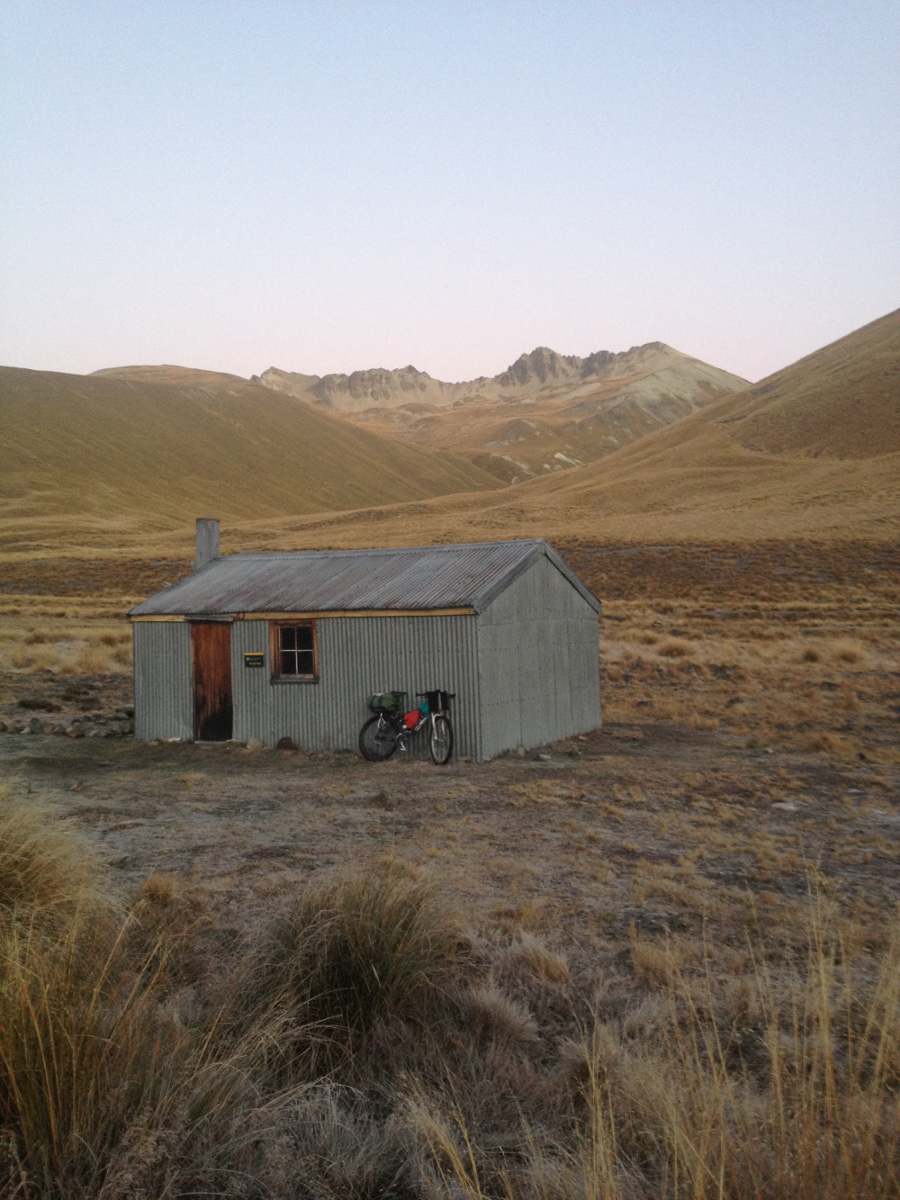
DOC happily provided me with station contact details and Mt Gerald Station half way up the east side of Lake Tekapo obligingly allowed me to cross their land and pass thought their deer gates and with their key in my pocket enabled me to ride and push up to Rex Simpson Memorial Hut (private) at the edge of the Roundhill Ski Field and the ridgeline north of Camp Stream. (My advice to anyone doing the Te Araroa trail is to follow the ridgeline from Rex Simpson Hut to Stag Saddle rather than the long distance trail in Camp Stream Valley). In reverse it would have been the most amazing 15 km downhill single and then 4WD tack downhill roll, but I was heading north and had to push.
The 500 m, 3 km, descent from Stag Saddle (the highest point on the Te Araroa at 1925m) to the eight bunk Royal Hut ranged from was barely rideable at the top, and technical tight on valley single track. Thank goodness I am at the hut as the evening was clear of clouds and the temperature falling fast. I was grateful for the DOC musterer’s hut on this night as the frost set hard on the ground. Carrying food for four and a half days, a tent and MSR stove, I had planned a circular route from Tekapo as it was late April and the chances of crossing the Rangitata were debatable on this trip.
I shared the Te Araroa Trail north for a couple of kms on single track through the tussocks and crispy, crunching frosted puddles, before turning east on the 4WD old pack route over Bullock Bow Saddle (1692m) to cross the Sinclair Range and the 4WD descent into Forest Creek. The DOC easement negotiations now enable mountain bikes to roll from Royal Hut to the Rangitata, but Ben McLeod farmers had had many problems with hunters and the exit from Forest Creek into the Rangitata has an awkward finish as travellers have to use the correct easement track on the valley side to the north. To my great delight I met a Ben McLeod shepherd on the track who gave me permission to exit on the flat valley private 4WD track across his land. I could keep on rolling down the valley with ease, in sunshine, watching the shepherds bring the flocks to lower pastures for the winter.
The Rangitata River was not looking crossable, even if I headed up river to the Clyde and Haverlock confluence at Erewhon. I have crossed four times previously here and knew the route across the river but instead I turned east and was back on a sealed road. There were many wild apple trees, heavy with fruit on the road verge, grown from throw away apple cores I thought. A 40 km ride to the DOC campground at Peel Forest. Hot showers, a zip, logs for the fire and a warm kitchen to myself to read in, this was glamping in style after 126 km of hard bike packing in two days. I planned to come back another day to link the Rangitata to the Rakaia.
I had asked permission the previous week from the Orari Gorge Station and Lochaber Station managers to cross their land by mountain bike via the Orari River Gorge, as my back-up plan if I could not cross the Rangitata. Both managers were agreeable, the later charging MTB riders $5 to cross. I gave a courtesy call asking if I could pass thought the next day.
A wee gem of a ride, I headed south from Mt Peel to Arundel, then north again from Orari Bridge. I was glad I had my food supplies and did not have to do a dogleg to Geraldine and could stay on the back roads away from traffic. I signed in at the station office and I thought I had listen to the instructions about how to get through the correct farm gates, but missed a section and instead of heading up the Orari Gorge road I followed Andrews Stream, a miniature version of the gorge road, and over a 850 m pass to descent Bernard Stream to Lochaber Station where a very large herd of cattle was bellowing in the stock yard waiting for the stock trucks to arrive to move them. I duly walked around the farm to find the farmer on a digger in the river flattening the river bed as stock trucks are now too large to cross the farm bridge and have to ford the river. I presented my $5 note and was offered the cook house to sleep in or the old farmhouse. The later was perfect as had an outside table and chair, a pleasant respite to have a back rest after a day in the saddle. A large fig tree with a flat area to camp under was desirable, until a possum decided it was his tree in the middle of the night and had a loud vocal session with me about ownership.
The fourth and final day was gravel and bitumen over Meikleburn Saddle and around Lake Opuha to Kimbell where I joined the main tourist road at Burke’s Pass to Tekapo. This backroad made beautiful gentle cycle touring on a still morning with yellow willow leaves glistering in the morning dew. As it was only a six hour ride I was able to catch the afternoon bus back from Tekapo back to Christchurch to fly home.
The second part of the trip took place five months later after more map study, weather watching and finding bus timetables that fitted in with flights to Christchurch from Wellington. The stars lined up, the country was going to be wet, but where I wanted to go the weather looked ok and the Methven Bus Company who usually do not take bikes were happy to obliged as was the low season. I caught the early flight, stocked up on six days of food and fuel in Christchurch and caught the midday bus to Methven and cycled 50 km along the south side of the Rakaia River Road and a name changed into Double Hill Road, pushed gently from behind by a tail wind. The Black Hill and Palmer Ranges loomed on my left side, joining the Arrowsmith Range while glimpses of the Main Range appeared in the distance at the head of the Rakaia River. I camped in the still air and slept deeply, My previous trip up the north side of the Rakaia River was a hitch with Tony Gazley in a jeep, which had saved hours of walking on river stones on our AP to MC tramp many years ago.
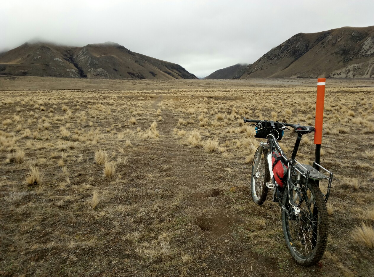
I had called Glenfalloch Station, Upper Lake Heron Station and Arrowsmith Station the previous week in regard to access and stock movements as wished to cross their land. The Te Araroa trail passed through this area, but further east, and I would re-join the trail near Lake Emma. Morning cloud made me damp but rain did not fall until my ride finished at Arrowsmith Station after a remote and rolling ride from the Rakaia, Lake Stream, Lake Heron to the campground on four-wheel drive tracks on private land. This heavily glaciated landscape was big and the sky huge. The DOC campground on Arrowsmith Station land has a six-month caravan season, and I arrived two days prior to the season starting on October 1st. Each site was marked out with wooden pegs and names. The station managers’ wife offered me the Shearing Shed instead for $20 a night; hot showers, a real kitchen and a heater to dry myself by as the rain started 10 minutes after I arrived – a bargain. A neat label on the wall of the tariffs stated mountain bike riders, walkers and horse rivers had a $10 land access fee if heading up valley on their farm tracks, as the area is popular to all. I stayed two nights so I could ride the Hakatere Conservation Park Mountain bike trails. The area is a brevet riders delight, kettle hole lakes, mustereres huts to stay in, ephemeral turfs wetland, threatened birds and lizards, beautiful red tussocks and thought rain fell in the hills I was dry in these vast valleys. The excellent Hakatere Conservation Park brochure can be downloaded with maps of tramping, biking and 4WD tracks.
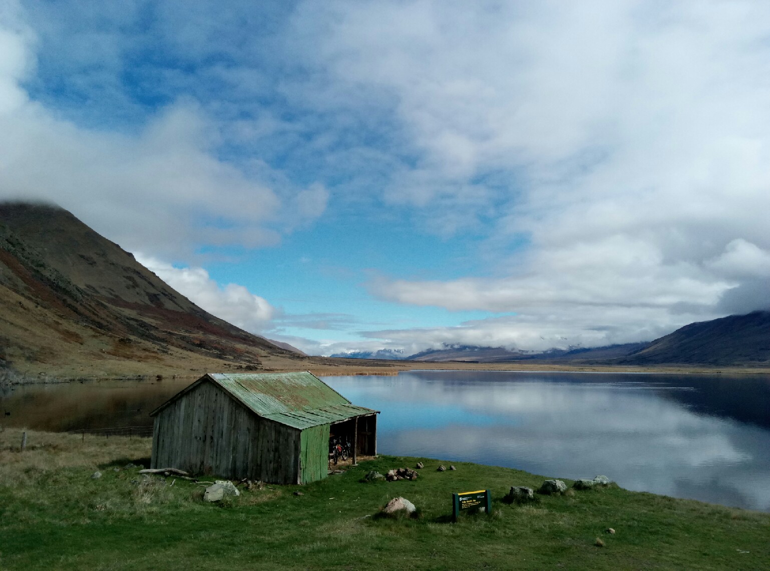
The promised day of sun appeared the next day and I hid my panniers near the Historic Lake Emily hut and rode out and back on gravel roads to Mount Sunday (of Lord of the Ring fame), on the edge of the Rangitata. I looked across the river to where I had exited Forest Creek on the south side five months previously. Did I really need to cross this river between these two points? I decided not, and returned to my panniers and enjoyed the next day pannier free day riding DOC marked MTB 4WD tracks to Paddle Hill Creek and Boundary Creek over the top to Mystery Lake and single track to Lake Clearwater. A week based in a bach at Lake Clearwater would make a lovely WTMC trip, but take all your food with you as its 40km to the nearest shop.
On my sixth day I left the park by the Ashburton Gorge Road and a fast tar roll dine to catch the afternoon Intercity bus back to Christchurch and a flight home. Now to plan the last leg of my South Island Traverse, the Rakaia to Lake Coldridge, Sumner Forest Park, Wharftdale Valley, then across the station that charges MTB riders $20 to cross his land to Hamner Springs. May be next year.