
Highlights
– The breathtaking summit of Mt Hikurangi and its cultural significance
– Winter Solstice fire ritual – letting go and inviting in
– Sunrise at Hikurangi Hut – with views that lingered, then 360-degree views of the East Cape and Raukūmara Ranges from the top of the Maunga
– Whāngārā Beach, bach, and blissful atmosphere
– Hot soak at Mōrere Hot Springs to round off the trip
Friday – 30 May
With boots packed and spirits high, a small group of four met a club EM group on Wellington train station at around midday on Friday of King’s Birthday weekend. With a long drive ahead, we started the trip with introductions and made our way up the North Island – winding our way toward Lake Waikaremoana. We made it to Waikaremoana Holiday Park at around 10pm – our base for the first night. The MF group camped, while the EM crew bunked in cabins. The wind that picked up that night was ominous.
Saturday – 31 May

Saturday dawned, clear but very windy. We drove the EM group to the start of their walk (the Lake Waikaremoana Great Walk) and then navigated along the East Cape towards Pakihiroa Station, gateway to Mount Hikurangi, Ngāti Porou’s sacred maunga. We began our ascent to Hikurangi Hut at around 2pm, near an impressive ‘retired’ waka.

The track rose steadily through farmland and after about 30 mins, we encountered a lone tramper heading down (Fionella). We got chatting and found out she had turned around due to the ferocity of the wind. We assured her it should be okay to continue and that she should tag along with us. Reassured, Fi decided to take up our offer and joined us. Then we were five!
The wind got stronger the higher we climbed – at times we were struggling to stand up, so we estimate they were in the order of 80km/hr. As the sun was setting, we veered off the main farm track for the last 20 mins or so. We reached Hikurangi Hut just as the sun dipped behind the ranges—an unforgettable welcome of colour and calm. It was good to be out of the wind!
The Hut looked like old musterers accommodation (similar to standard DOC backcountry huts), albeit with a little more character. We spent a chilly night there (as the fire never really took hold), with one other person (whose name I’ve forgotten), and enjoyed a meal of chickpea and carrot tagine, with chocolate brownies and custard for dessert.
Being the shortest day of the year, Fi shared a winter Solstice ‘fire ritual’ with us, which she said she had bought with her from Ireland. This beautiful and symbolic tradition is the “burning of wishes and fears”—a communal or personal ritual that marks both release and renewal during the longest night of the year. Participants write down two things:
- A fear or limiting belief they want to release (e.g. worry, resentment, regret, or emotional baggage), and
- A wish or intention for the year ahead (something positive they hope to cultivate—joy, courage, connection, purpose).
We each spent some time reflecting on these things, then, one at a time, cast our paper into the fire. Supposedly, the fear burns first, symbolising ‘letting go’. The wish follows, rising as smoke and light toward the dark solstice sky—a visual invocation of renewal, transformation, and hope. For me, this was a powerful reflection exercise, made even more memorable by the special location and the shared camaraderie with fellow trampers.
Stats:
- Distance – 10.7 km
- Elevation gain – 970 m
- Elevation loss – 0 m
- Elapsed Time – 3 hrs 16 mins, Moving time 2 hrs 7 mins
- Depart Pakihiroa Carpark 2pm
- Arrive Hikurangi Hut 5.25 pm
Sunday 1 June
Dawn broke crisp and clear—some of us woke early to take photos of the sunrise. The previous evening, we had considered walking up to the summit for sunrise, however the wind howled all night and still had not abated by morning. Luckily, the forecast was for the wind to ease. So we had a leisurely breakfast and then headed off.


Mount Hikurangi, standing proud at 1754 m, was calling. As we climbed above the Hut, we removed layers. Our friend from the previous evening was returning to the Hut as we were climbing and reported fierce winds. Regenerating bush transitioned to native bush and then tussock-covered terrain, as we gained altitude. As we sidled around the Western side of Mt Hikurangi, there were several small tarns and potential camping spots.


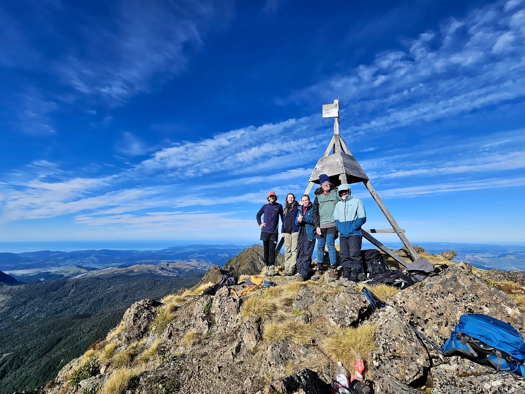
The last section of the walk involved a climb up a narrow rock / scree gully towards the summit (hence the MF grading). Although there was a warning sign about falling rocks, we didn’t feel the need for helmets, as long as we spaced ourselves adequately. The final section along the crest towards the trig was also very exposed, with some steep drops-offs on either side. Luckily, by the time we reached the summit, the wind had largely dissipated.


Views across the Raukūmara Range and the East Coast were simply stunning—a real moment of connection with place. Sara and Josh put their trip planning hats on and thought it would be great to put a Raukūmura Traverse on the schedule at some point – perhaps with another group basing themselves at Hikurangi Hut and bagging a number of other local peaks (Aorangi 1273m, Wharekia 1106m and Whanakao 1618m, naming but a few). These peaks are a unique feature of the area; the isolated high points caused by tectonic forces lifting older basement rocks, along with erosion of softer sedimentary layers.


We met another lone tramper while we were at the summit – a local forestry worker, Angus. He told us about the impact of slips and landslides on forestry operations in the area, in particular after Cyclone Gabrielle. We hit it off and he joined us for the rest of the trip – and then there were six!
After soaking the vistas up and snapping obligatory summit selfies, we descended back to Hikurangi Hut for a cuppa, packed up, and returned to the van at Pakihiroa Station.


On the way back down, we stopped at the carved whakairo near the Hut, at 1000m above sea level. These were erected in the lead up to the Millennial celebrations. The nine whakairo lend cultural richness to the rugged landscape and depict Maua-Tikitiki-a-Taranga and his whanau. Maui is an important ancestor of Ngāti Porou. The story goes that Maui fished up this land from the sea; his canoe is in petrified form on Mount Hikurangi.
We arrived back at Pakihiroa Station carpark after dark, then headed South to the coastal haven of Whāngārā, where Josh’s family’s retro beach bach welcomed us with open arms.
Whāngārā is the location where the movie ‘Whale Rider’ was filmed. The film was inspired by the legend of Paikea, the whale rider.
After a late arrival, we made another tasty recipe from the club cookbook – vegetables and feta with couscous. Later that evening we said farewell to our new tramping friend, Fi.
Stats:
- Distance – 18.5 km
- Elevation gain – 660 m
- Elevation loss – 1624 m
- Elapsed Time – 7 hrs 34 mins, Moving Time 3 hrs 55 mins
- Hikurangi Hut to Mount Hikurangi – 8.30 -11.00 am
- Return – 12pm – 2.15 pm
- Hikurangi Hut to carpark – 3- 5.30 pm
Monday 2 June
We woke to another stunning day in a glorious setting. Our final morning was gloriously unstructured; coffee on the deck, and barefoot wanderings along Whāngārā’s beautiful windswept shoreline.


After coffee on the deck, Josh and Ella took a dip, while Harry recited some Robbie Burns.


On the way back to Waikeremoana, we detoured to Morere Hot Springs, stopping for a quick dip to ease our sore legs in the natural hot springs.
On our way south, we reunited with our EM group who’d been adventuring around Lake Waikaremoana. We then made our way back to Pōneke with tired legs and full hearts, arriving after 11pm.
Ngā mihi to everyone who joined us along the way. Angus and Fi – it was great to meet you and welcome you as honorary members, if only for a day! And to Josh and his whānau for sharing their incredible coastal retreat.
This trip blended mountain magic with East Coast hospitality and amazing mountain and beach vistas, reminding us why we tramp: for the challenge, the camaraderie, and the connection to the land.