
Ivory Lake – a hiking trip through spectacular west coast NZ scenery.
A 10 day hike through Westland National Park to visit Ivory Lake and its icebergs.
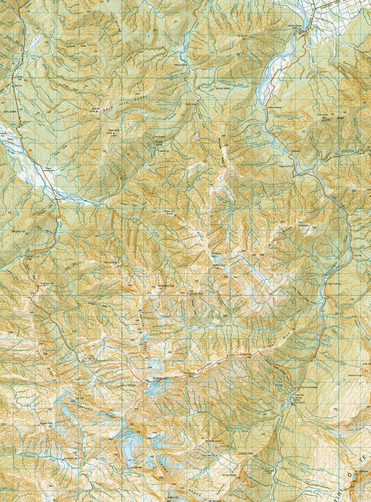
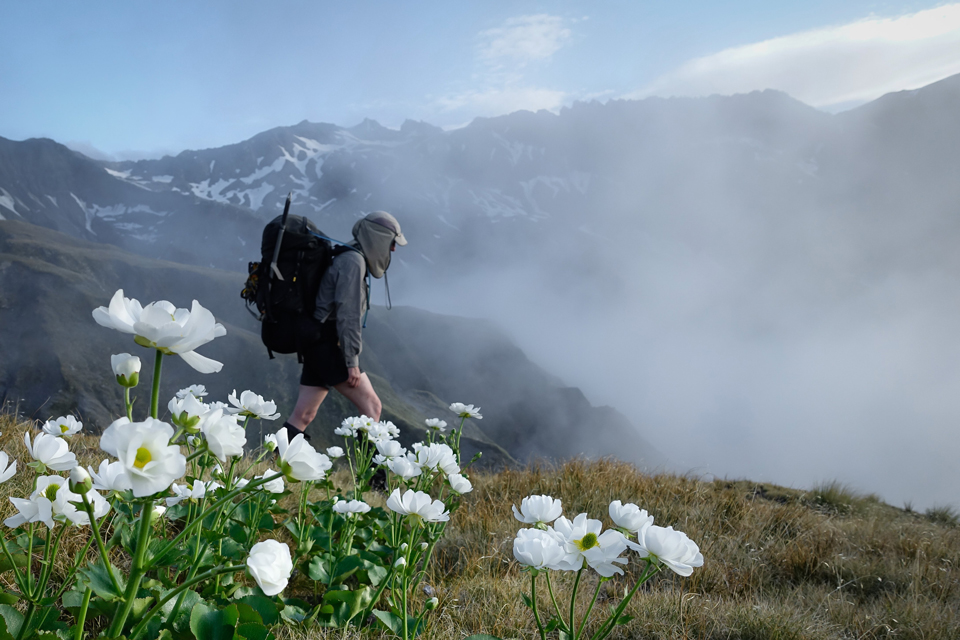
Day 1: 23rd Dec 2017 – Hokitika Gorge to meadow campsite (45 mins)
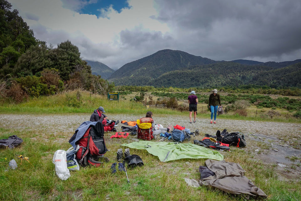
We arrived in Hokitika eager for shade and faffing time. Having driven from Picton that morning, we had a couple of hours to faff, eat our last non-dehydrated dinner for a while and get ourselves to the Hokitika Scenic Tours HQ from where Rachel was due to drive us to the Hokitika Gorge (scenic it was) road end.
Gear shuffling was completed under a tree at the local domain, with weight distributed unequally but appropriately for each of our five frames to be capable of at least maintaining a standing stance with our packs. We were carrying ice axes, crampons, a 30 m rope and a mountain radio between us as well as food and fuel supplies for the nine days ahead.
We lucked out with our transport arrangements and managed a ride a few kilometres along the first section of four-wheel drive track beyond the gorge car-park right to the start of the Whitcombe Pass route proper, complete with green-and-yellow DOC sign etched with ludicrously enthusiastic track times for the first few days of our journey.
Stepping out on the track at 7 pm allowed just enough time for each of us to identify which straps of our packs were going to chafe against which body parts before we found a suitable camping spot 45 minutes later. Sandfly defence tactics were immediately deployed. While we sipped on our evening brew discussing plans for the adventure ahead a couple of hunters in an old-style four wheel drive drove pretty much straight through our campsite hoping for some Christmas venison from the other side of the locked cableway that crossed the river just nearby where we had camped. I didn’t hear their vehicle return so I must have slept well that night.
Precarious features of day one were mostly along State Highway 6 and now behind us along with other joys of civilisation like showers and fresh fruit.
Day 2: 24th Dec 2017 – Meadow campsite to Frew Hut (6 hours)
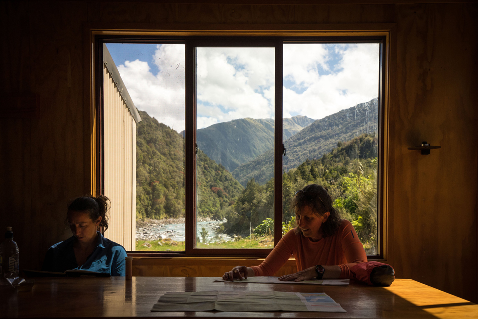
Today the trip proper began. The first three or so kilometres were easy enough along benched track and river bed. We were all taking it slow knowing we had all day to reach Frew Hut and needing time to settle in to carrying a heavy load. We had fun winding each other across the cableway to reach the opposite side of the Hokitika River. A few hundred metres down the track was Rapid Creek Hut where a possum trapper and a chamois hunter had spent the night. We chatted for long enough to feed the sandflies and get what information we could about the state of the track ahead.
Shortly after the hut we took a right turn up the Whitcombe, and I spotted a distant orange triangle which allowed us to remain in the river bed rather than worry about locating the track on the terrace beside us. Turns out I am good at spotting orange triangles and the team often sent me ahead as a scout in the days which followed.
The river valley narrowed into the Collier Gorge. Mostly we were sidling on the track above the river, but there was the odd section of boulder-hopping (‘hopping’ isn’t a very accurate description given these were classic West Coast house-size boulders, some of which required packs to be passed up and over). Somewhere along this section Megan located a precarious notch between some tree roots to wedge her boot into. The result was a sadly unwitnessed back-flip with a happily safe landing aided by her spine-protecting ginormous pack. There’s a swing-bridge to get you to the other side of the river half-way along the Collier Gorge – the bridge is so precariously high there’s a ladder to descend to reach the river bed on the far side. At Frew Hut we read of a previous bridge being washed away which perhaps justifies the height of the current one. Just before the hut we caught up with the lone hunter we’d met at Rapid Creek. He was smiles all over as he described to us all the gold he’d seen…until one of the geological experts among us pointed out it was likely Fools Gold….sorry mate!
We arrived at Frew Hut around 2pm, just as the heat of the day was becoming too much. We all retreated into the cool of the hut for a snooze not quite believing we were on the West Coast.
Later we braved the sandflies (reminding us that we were indeed on the West Coast) to set up the radio aerial so we could listen to the forecast. With rain due the next day we opted for a hut day, so no alarms were set as we settled into our sleeping bags on Christmas Eve.
Day 3: 25th Dec 2017 – “Rain” day at Frew Hut
So we’d done one day’s walking and now it was time for a rest day already. This Westland Christmas tramping lark was alright! We spent Christmas Day snoozing while waiting for the next billy to boil and peering at the clouds waiting for the forecast rain to justify our prolonged presence at the hut. By mid-afternoon we were beginning to get a bit restless and starting to worry we’d wasted a dry day when we could have been making further progress up the river. But we needn’t have worried as it did indeed start raining, and the forecast again said it would be clearing tomorrow so we’d be good to continue then. The Percival Guildhouse Christmas 2017 Fundraiser Quiz sent by my aunt in England distracted us for a while as we tried to decipher the cryptic clues which supposedly described everyday implements….”Mixed little waves without one vegetable (6)” anyone?
We also poured over the photocopied version of the hut book from the 1970s, spotting several familiar names including a young Tony Gazley with a large party from WTMC also on a Christmas trip. We noted the absence of any mention of intentions to go to Ivory Lake before coming to the conclusion that the hut was only built in the mid-70s and even then for scientific purposes rather than as a destination for trampers.
Having the hut to ourselves, we challenged each other to a table traverse, a hut traverse and a broom traverse – it’s difficult to say which of these traverses was the most precarious. A few bruises and some well-flexed muscles later, it was time for the deliciousness of dehydrated pulled pork and salsa which made a fine Christmas dinner. Then more sleep….as if we hadn’t had enough over the past 24 hours.
Day 4: 26th Dec 2017 – Frew Hut to Price Flat Hut (6½ hours)
We planned on a lazy start to ensure the rain had passed and the side streams we needed to cross up ahead had a chance to drop. Megan had placed some marker stones in Frew Creek the night before – these had been washed away overnight but the creek was back down again and easily crossable.
We were surprised by the quality, and unprecariousness, of most of the track along this section. Most of it was wide and flat, the kind of track suitable for rolling out carts of gold. However, just to make sure we didn’t get too complacent, the crossing of Vincent Creek involved my first three wire bridge, and the associated precarious nature of boot-placement required for a non-slip passage. There were also a couple of never-ending slips to negotiate. Some of the sidling to the marked exit points was somewhat precarious, with the Whitcombe racing below. I was thankful we were travelling up the river on a dry day.
Just before the current Price Flat Hut is a historic cedar slab hut, which appeared reasonably habitable if you were happy to spend the night with a mummified possum. We opted to check out the new hut a further ten minutes up the track, but hung out with the possum for a few minutes to dodge a rain shower and avoid putting on our parkas for yet another day on the glorious West Coast.
Safely at Price Flat Hut we were treated to another photocopied version of the 1970s hut book – this time Tony’s name appeared a second time on a different trip which he’s still trying to recall despite confirming the handwriting is his.
From both Frew and Price Flat we had views of our upcoming challenge, the 1100m climb onto Steadman Brow.
Day 5: 27th Dec 2017 – Price Flat Hut to campsite on Steadman Brow (6 hours)
We started early, anticipating a hot climb and keen to keep our options open for making as much progress as possible towards Ivory Lake. We first retraced our steps for a kilometre, back to the Price Flat footbridge where the Steadman Brow Access Route began. Hut book accounts of this access route were mostly positive, with the track having been re-cut relatively recently so we were hopeful our energy could be focussed on hauling still heavy packs upwards rather than route-finding. It was a long slow climb, with plenty of hauling required, and plenty of tree roots used as handholds and footholds. In general, the track was easily followable, but we were puzzled that as we reached the bushline the orange triangles clearly directed us downwards losing at least 100 of the 900 meters we must’ve gained by that point. They spat us out into a dry creek bed which we thought was the least likely spot for downward-bound trampers to be looking for the track start point. After we’d got over the fact that we’d now need to re-gain that 100m we’d just lost, it was quite a fun ascent up the dry creek bed and through the tussock to the ridgeline. A couple of big slabs in the creek provided a comfortable level of precariousness, just enough to keep our minds on the job.
On gaining the ridge, I looked right and saw a cluster of tarns on a flat section about a hundred metres further down the ridge. We knew there were tarns up here, described as being just below Cropp Knob, but I wasn’t expecting to have to descend to them. We re-grouped for lunch out of the wind and Megan scouted ahead for evidence of further tarns. Our only other option for water was to continue up Steadman Brow until we reached the snowline, but after the climb we’d already done none of us were relishing that thought. Within 20 minutes Megan was back with positive news – there were more tarns just a short way ahead so we could make a little more progress after lunch but a suitable camping spot was not far away.
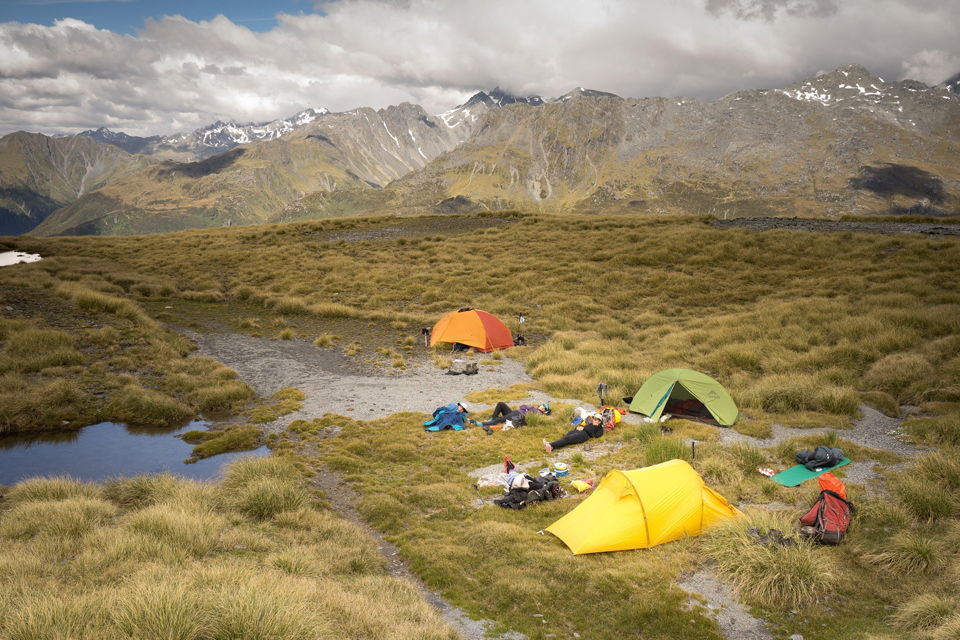
Within an hour we had each selected the best tarn-side campsites for our individual tastes. The rest of the afternoon was spent lazing in the sunshine, stretching out our climb-tightened leg muscles and attempting a few more Percival Guildhouse brainteasers such as “Size up with a steam puree (4, 7)”.
Later in the evening we were joined by eight kea as we experimented with erecting the radio aerial on walking poles given the lack of trees. Once again the wonderful mountain radio service reported that Westland would be “fine with light winds”. Just what we needed for the next two days on the tops.
Day 6: 28th Dec 2017 – Campsite on Steadman Brow to Ivory Lake Hut (12½ hours)
As we broke camp under a cloudless sky at 8am that morning I am not sure any of us appreciated how long and challenging a day we had ahead of us. Today was the day we were going to get to Ivory Lake Hut. We had fine weather. All we had to do was continue up along Steadman Brow, over Mt Beaumont, then take a left, another left, then a right to navigate along the ridges which would lead us down to Ivory Lake. The route guide suggested there was one down-climb which may be tricky but we weren’t letting that worry us.
In the first kilometre of so, before we reached the snow, there were a couple of notches which appeared out of the seemingly gently sloping wide ridge. The kind you assume will just reveal themselves to be a benign dip between two more substantial sections of the so-called brow once you can actually see them properly. The first was this kind of notch. The second notch was conquered without a thought by Illona and Kate. I looked up from the dip at the bottom to see Kate somewhat awkwardly straddled over a rock as she stretched to achieve the hand and foot holds she needed. I headed up to the same spot, conscious that I would likely to recreate Kate’s awkward straddle.
I tried several options, all of which felt too precarious to risk hauling myself into with my heavy pack. Megan called ‘do you want to take you pack off?’ from below. That sounded sensible except for the fact that we were now stood in a very exposed spot so this was going to be a bit of an operation. ‘Hold on a second’ Megan said, ‘I’m just going to get this rock out of the way’. I stood facing away from her imagining the whole mountain toppling down into the valley a kilometre below as she extracted the one piece of rock holding this precarious Jenga-tower of a mountain together. Rock moved and mountain still standing, she was able to rest my pack in a suitable spot while I climbed over the awkward bit. In the meantime, Illona had re-joined us to lend a hand. On the upper side of this exposed section, which was still narrow and exposed in itself, we now had two people. Megan passed up my pack, so that made two people and one pack. Tony passed up his walking pole, then he decided he’d also not risk the manoeuvre with his huge pack, so his pack was passed up too. Two people, two packs and a pole. As Tony started to climb up, I realised three people, two packs and a pole would be too much for this particular spot, so Tony’s entrance was halted. Illona ferried my pack up the rest of the section, and I wedged the walking pole down the back of my t-shirt so I could use all my hands and feet for the rest of the scramble up.
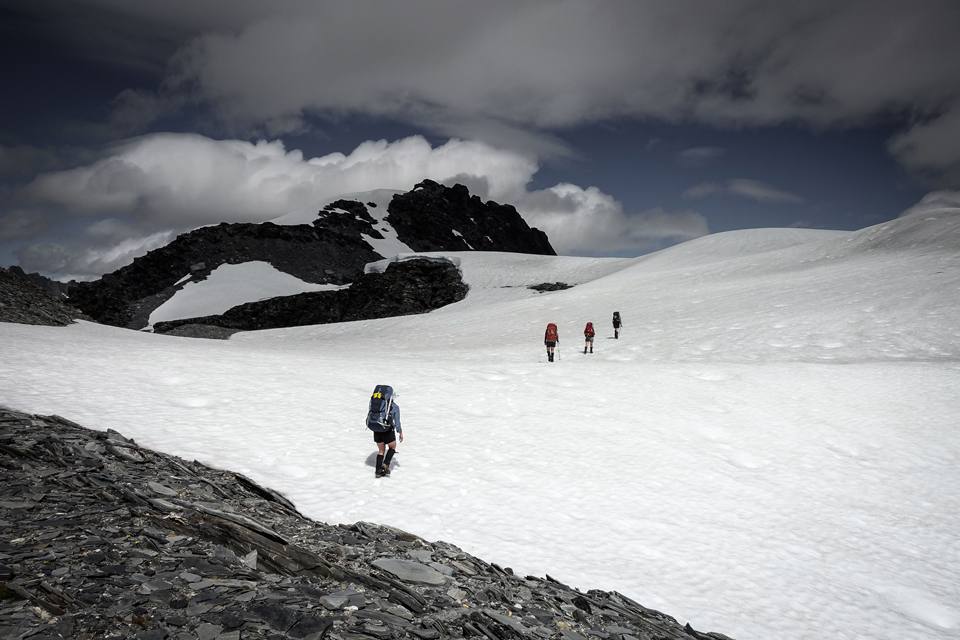
Thankfully the rest of the journey along the ridge to the summit of Mt Beaumont was generally quite nice travel. After an early lunch stop we donned crampons. There were some narrower bits, some steeper bits, and some rocky bits, and some fantastic cornices to be avoided but overall the next couple of hours approaching the summit was straightforward. It was a little windy at the top so we tucked down on the Tuke Valley side of Beaumont for a snack and to identify our next ridge which would take us further towards Ivory Lake. It was 2pm. There was some cloud floating around, which seemed to be adept at clearing just when we needed to see where we needed to go next, then filling in again. Around this point we picked up some fresh footprints heading in the same direction at us. At least we had a few hours to get used to the fact that we’d likely be sharing Ivory Lake Hut that night. The footprints proved handy at a few spots, helping us to identify the easiest way around some of the obstacles on the ridge more quickly than we might otherwise have done.

The junction with Sawtooth Ridge came and went, with a nod to the cairn, and a sense of relief that we weren’t needing to negotiate travel along the teeth of the saw themselves. Now we were at the “short, down-climb of around five metres just before point 2084m which is exposed, crumbly, and would be problematic for many” and it was clear that we were in the category of people who would find it ‘problematic’. In fact, we think pretty much everyone would find it problematic. There was a small rope someway down, but the state of the surrounding rock meant none of us had any faith in it so we weren’t even going to attempt that option. Megan and I scouted lower down the couloir and identified a series of linked ledges that allowed us to descend to the gap between the snow and the rock. Megan and Illona wedged themselves into said gap, and Illona donated her shoulder as a stepping stone for the rest of us to make the long step onto the snow filling the couloir. Packs were passed, ice axes were placed, and some shimmying up, down and along the crack was performed before we were all safely beyond the most precarious obstacle of the trip so far.
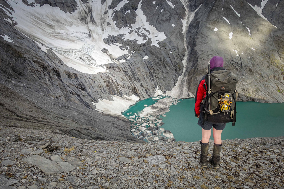
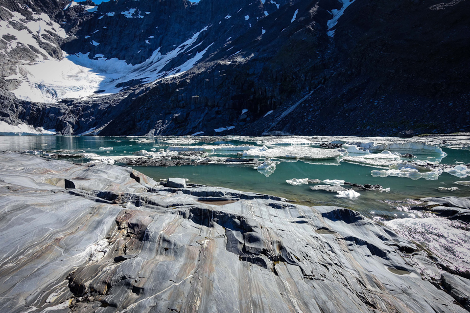
Not much further along we reached the junction with the next ridge and were rewarded with the view down onto Ivory Lake and the hut, still a long way below us. Crampons were re-donned at this point for a narrow snow-covered ridge which more than one us found a little uncomfortable. Then we headed down the ridge quite steeply but inside corridors of rock which at least felt a little less exposed.
The last obstacle came further down the ridge, and quite a while after we’d all thought we were past the hard stuff. It came in the form of another hidden notch, not dissimilar to the once we’d faced early in the day. Except now we were all much more tired, and to me the climb back out of the notch looked like am impassable overhang. The descent into the notch wasn’t exactly easy either, but taking a snack break in the middle, where I could sit and allow my brain to imagine what would become of me if I failed at the overhang section, perhaps wasn’t the best idea. Turns out it was fine, and there was a grassy chute to one side which was perfectly climbable without even going near the overhung section.
It was still another hour or so of steady plodding down the ridge towards the hut which we reached about 8:30pm. Crossing the lake outlet was uneventful and seemed a breeze after what we’d come through. On the way down, conversation had turned to the next day. It was clear none of us were relishing the thought of our original plan to return to Mount Beaumont and drop down to Top Tuke Hut. Top Waitaha Hut, a much shorter and easier day, seemed like a more inviting option, but then that would commit us to the long trek out via the Waitaha which has developed somewhat of a challenging reputation. After we all had some dinner inside us, returning up the ridge to Beaumont seemed less daunting and the more sensible option overall. Exhausted and ecstatic to have finally reached Ivory Lake Hut we were all tossing and turning for an hour or so processing the day we’d have before any of us could sleep properly.

Day 7: 29th Dec 2017 – Ivory Lake Hut to campsite in the Upper Tuke Valley (11¾ hours)
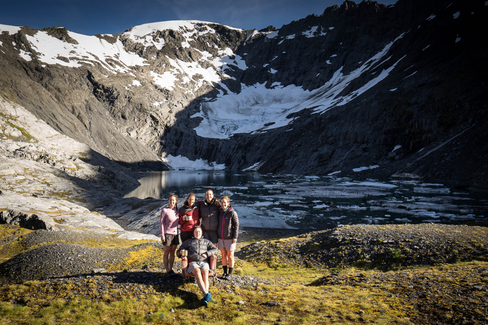
Not wanting to leave this wonderful spot, especially on such a still and sunny morning, we took our time getting up. We breakfasted on the slab rock outside the hut, took the obligatory photos with the famous armchair, and of course proudly wrote our names in the hut book.
Heading back up the ridge on fresh(er) legs was manageable. That notch which had stumped us on the way down only became a stopping point for the second time because Illona accidentally sent her walking pole flying down for a closer look at the lake edge. We seized the chance to use the rope we’d been carrying for the whole trip. Tony body-belayed Illona as she stirred up a dust cloud to retrieve the stray pole.
It was hot going, and we resorted to snow under our sun hats to enjoy the cold drips that it melting produced. Almost at the top of the ridge, we stopped for a precarious lunch wedged against the shadiest rock we could find. Not only were we melting on the West Coast, but we had also now visited Ivory Lake Hut. Pinching myself to believe it seemed appropriate.
We re-negotiated our way past the tricky point just after Point 2084 much more quickly than yesterday now we knew the best route. I was starting to lose track of how many times Illona was standing there waiting to support me over a tricky bit – this time holding out her hand to give my ice axe a gentle tug to give me the momentum I needed for a larger-than-comfortable step up.
Somewhere along our second traverse of this ridge, I had a narrow escape from the wild bears that must live in these parts. The long rip in my shorts which were now precariously hanging on by a thread was the only evidence that their attempts to maul me had failed. What was that I was saying about having to keep pinching myself?!

Back just below the summit of Mt Beaumont we identified the spur that would lead us down into the Upper Tuke. It was already almost 6pm and we briefly considered bivvying near the summit rocks. There was cloud around so we couldn’t see too far down, but our friends from Ivory Lake Hut had left a few cairns which probably saved us a good couple of hours as we found our way down.
The journey down into the Tuke was one of the most delightful parts of the trip. The light was wonderful, with mist coming and going to add to the atmosphere, and as the terrain turned from rock to tussock we found ourselves in a steep meadow of Mt Cook lilies. The lilies and the jet-planes I doled out lifted our tired bodies enough to continue our descent. We could see the hut but it still looked a long way away and we got out our head torches as we anticipated some travel in the dark. Looking down at the river, a certain arrangement of stream junctions and boulders appeared to me as a ‘No Entry’ sign…perhaps the valley knew we wouldn’t make it that far tonight.
Prompted by a remark from Tony as we passed a puddle of a tarn, Megan identified a plateau below us that looked like the perfect camp spot. If one had been sauntering past this spot at 3pm in the afternoon on one’s way to Top Tuke Hut, one might have considered it too bog-like to make a suitable campsite. At 9:15pm, in fading light and loitering clag, after our second twelve hour day in a row, it looked to us like a five-star-hotel-with-king-size-bed-and-infinity-pool-kinda-campsite!
Day 8: 30th Dec 2017 – Campsite in the Upper Tuke Valley to Top Tuke Hut (1½ hours)
This morning we took it slowly, having decided that all we’d demand of ourselves today was to get to Top Tuke Hut. It was a damp morning, and our muscles were feeling the effects of the previous days.
In the daylight it took us not much over an hour to reach Top Tuke Hut, through tussock with plenty of Spaniard and hidden holes to contend with. We spent the rest of the day snoozing, sewing bear-mauled shorts, rubbing voltaren into sore knees and generally enjoying not clambering up and down crumbly ridges.
Having fashioned a somewhat precarious aerial holder using a walking pole, a spare shoe lace (this must be why everyone needs one in their emergency kit!) and a nice forked branch, the evening sched confirmed we’d likely be walking in the rain the next day. We decided we could get away with sleeping in the hut on this side of the Tuke that night, as our only river crossing was early on in the day.
Day 9: 31st Dec 2017 – Top Tuke Hut to Dickie Spur Hut (8½ hours)
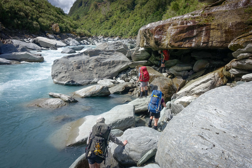
Today was wet. It was raining for most of the day, and if we weren’t in the river negotiating our way around boulders we were pushing/squeezing/wedging/scratching our way through rain-soaked bush. Tony described the Upper Tuke River as a “miniature Waitaha”. Mini Waitaha was enough for me so I was glad we’d decided to on this option. In one of the river sections we spotted two whio which we managed to follow as they played in the rapids for a few hundred metres before they got too far ahead and we were forced back in to another section of bush-bash.
We stopped for the shortest possible lunch break, but even a few minutes of rain exposure was enough to turn my Tararua biscuits a bit slimy…I guess I should be thankful they weren’t too dry! As the Tuke River turned into a steep-sided gorge, the orange triangles took us up a stream bed all the way onto Dickie Ridge some 500m above. It’s rare to be able to travel from bottom to top all the way in the stream bed like that and it was very enjoyable travel. There were numerous small waterfalls to be climbed, but unlike the crumbly rock from earlier in the trip, these flowing sections were solid and blocky which made for neat hand and foot holds. It was a fun ascent, but we were all pretty soaked and tired so may have been guilty of not appreciating it’s beauty quite as much as we would’ve done on a sunny day.
We reached Dickie Spur Hut about 4:30pm after a minor yet monumental lapse in our collective navigational nous which probably cost us half an hour on the tops – not something any of us enjoyed at that point in the day.
While Illona celebrated the one dry section at the top of her t-shirt, the rest of us busied ourselves wringing out the water from all our other items of clothing. My fingers were wrinkly and my shorts had reverted to bear-maul mode. But we were soon warm and dry and ready to see in the New Year in style…tucked up and sleeping soundly waaaay before midnight!
Day 10: 1st Jan 2018 – Dickie Spur Hut to Mikonui Flat Road End (8 hours)
We made an early start to allow us plenty of time to meet our 4pm road-end pick-up. We definitely didn’t want to keep Rachel waiting and we even more definitely didn’t want to miss out on the cold cider and warm shower awaiting us in Hokitika.
The cloud was still clinging to the ridge but it had stopped raining when we left the hut. We had a steep 700m descent down the Dickie Spur Route. This was the most-cut and marked track since we’d left the Whitcombe so travel would have been easy were it not for our weary legs. After several hours, including some precarious tree fall negotiation through which some of us choose remarkably better routes than others, we popped out back alongside our friend the Tuke River. It was running clear again, having got murkier and murkier to the point where we’d left it the day before.
Most of the riverside travel was easy going along the flats, but there was the odd section which diverted us back into the bush, albeit along relatively well-marked and cut track. Right at the end of the river section there was a short distance of chain strung along the rock to minimise the precariousness of the short but steep sidle above the gorge to the swing bridge. This marked our final goodbye to the Tuke and the start of a much-debated 100m up-and-over. The debate was around how long it would take us, and its settlement involved a start-line, a stop-watch and the payment of a bet worth two precious M&Ms.
We took a quick break to write in the hut book at Mikonui Flat Hut, then headed towards the river to find a suitable combination of braids to make a safe crossing. With flows back to normal after the previous day’s rain, it was a straightforward but linked-up crossing. Then came a few kilometres of four-wheel drive track, passing a historic homestead, to get us to the road end.
We were pretty pleased to have completed nine full days of tramping in good conditions on the West Coast, and to have reached our Plan A destination of Ivory Lake Hut. Precariously jammy or what?!
For more Ivory Lake photos go to www.tararuaphotos.com ⇛ Other tramping photos
Hello from switzerland,
i hike there in winter 1990 whith 2 americans.
At this time the hut had a blue color.
The glaciar in the back was one piece and not separatet from the part above.
Very nice fotos from the area.
Thanks a lot !
Hans joerg