
The plan for this weekend was concocted because we were unable to access Ruahine Forest Park from Mangakukeke Road end.
Anne de Ferron suggested an inspired alternative: a traverse via the newly relocated Leon Kinvig Hut. This idea would allow enable two Medium Fit (MF) club groups to do a key swap and enjoy excellent tops travel and hut bagging opportunities. With a near-perfect weather forecast, we met an Easy Medium (EM) group from the club, who were heading the same way to go on a trip, at Wellington Train Station at 5pm on Friday and set off.
The west to east MF group (consisting of Ellis, Josh and Tiffany) continued on north in the Club van to Petersons Rd, while both the EM and other MF group (11 punters in total) had an easy 30 min walk to Alice Nash Memorial Heritage Lodge (the Lodge). They were relieved to find only two hunters at the Lodge – leaving plenty of space.
The east to west MF group, comprising Jess and the triumvirate of Jameses (yes, this created a lot of confusion and we failed to come up with a system of nicknames), drove to Anzac Park in Norsewood. This spot provided a cheap place to camp for the night and has the following facilities: picnic tables, toilet facilities and (untreated) water. The canopy of a large tree kept tents dry overnight, and a surprisingly good sleep was had despite mooing cows, scrapping possums and rumbling trucks on nearby State Highway 2.
Saturday
Departing Anzac Park at around 8 am, our east to west group drove to Moorcock Saddle at Kashmir Road end. Kashmir Road is in fairly good condition and there were only some minor rutted sections on the final steep climb to the carpark.
The Toyota Aqua made it up this climb valiantly, only bottoming out once. The east to west group began the walk shortly after 9 am, descending down to Awatere Hut in about 45 mins. We had intended to bag the dilapidated Black Stag Biv 250 m downriver, but were too relaxed walking down the sunny river flats to remember this objective. We overshot the Biv and then decided to push on, leaving the riverbed at the confluence of the north and south branches of the Makaretu River, to head to Happy Daze Hut in time for lunch. James H, keen to pad his hutbagger account, investigated a nearby 4WD track leading to Stacker’s Hut, but encountered a gate blocking access.

We left Happy Daze Hut at 12:30 pm, and headed up the northern branch of Makaretu River, reaching Makaretu Hut just over an hour later. This was the pick of the river huts and made for a good group selfie. All river travel this far had been straightforward – relatively small rocks, few log-jams, and low water levels after the dry weather. James D made it along the length of the Makaretu River only getting one sock damp, as he rock-hopped his way across the countless crossings.
From Makaretu Hut, we faced two route options to the Ruahine Range. An old unmaintained track behind the Hut takes a more direct route. As there was a new hut book at Makaretu Hut, there were no comments about the state of this old track, so we decided to take the marked track up the spur to point 1164.
Despite initial tree-fall and overgrowth on this marked track, travel improved with elevation. Unfortunately, travel from point 1164 to the Apiti Track junction proved unexpectedly slow. The otherwise wide-cut track runs under a Leatherwood canopy that constantly snagged our packs, requiring us to crouch and duck our away along the range. The slower progress did offer one silver lining: gorgeous views of the Ngamoko Range as the sun set behind it. We donned head torches halfway down the descent to the Old Leon Kinvig Hut site.
All that remains of the site is the concrete fireplace pad, perched precipitously at the riverbank’s edge. We spotted rubbish embedded in the riverbank below the old hut site – presumably buried long ago and now exposed by erosion. By head torch, track markers to the new hut site 700 m downriver were nearly impossible to spot. But we made steady progress on the river flats, crossing the river every 100 m or so. We found PVC pipe from the hut’s spouting tangled in a bush – a reminder of Cyclone Gabrielle’s destruction two years prior. While examining this, James H spotted a Whio fly past in the dark.

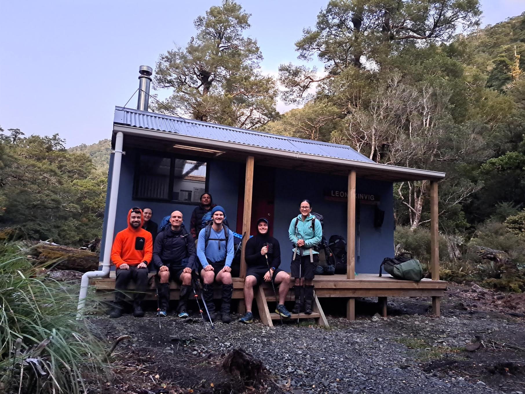
We reached the new Leon Kinvig Hut location at around 6:30 pm. We were fortunate that the west to east group had beaten us to the hut – we spotted Ellis’ head torch as he was collecting water from the river and he pointed us in the direction of the hut.
Leon Kinvig Hut has been extensively renovated by the Backcountry Trust after its relocation, including re-cladding, a snazzy blue paint job, installation of new windows and bunks, as well as a new deck, woodshed and toilet. The Hut’s book showed frequent visits by other keen trampers, demonstrating that despite its isolation, the Hut is much loved. The 8-bunk hut accommodated our group of seven cosily as we enjoyed dinner and toasted marshmallows in the fire, sharing stories from our day.
The west to east group had started their day early (at 7 am), heading first to Iron Gate Hut along the sidle track which includes a number of slips that must be navigated. One particularly large slip featured a step that had to be climbed – this would be trickier to do when travelling in the opposite direction. Elsewhere, there were pink ribbons along the route which marked detours around other slips and windfall.
The west to east group reached Iron Gate Hut in a speedy 2.5 hrs. It took another 2.5 hrs to climb to the Ngamoko Range junction, just south of Otumore (a high point on the range at 1519 m elevation). The group had lunch here in the sun, with stunning views -including a view of Mt Ruapehu peeking out from behind clouds.
Travel south along the Ngamoko Range was straightforward at first, but became more technical and slow-going after reaching Tunupo peak (at 1568 m elevation). About 15 mins south of Tunupo, there was a tricky down-climb. And by the time the group reached the turn off, it was too late in the afternoon for a side trip to Toka Biv.

The track down from Toka peak to the Pohangina River made for exciting travel, as it dropped steeply beside the edge of a slip. From there, it took 30 mins of travel down-river in the dark to find the new Leon Kinvig Hut location.
The group had been frequently distracted by possums – including one they saw just before reaching the Hut, which meant the giant orange triangle pointing to the Hut turnoff was missed. The group continued down-river and scrambled directly up the bank to the Hut, as they had not seen a set of nearby steps.
Sunday
Both groups stayed the night at the new Leon Kinvig Hut location and set their alarms to wake at 5.45 am for a 7 am departure. We expected it would take a little longer for everyone to get ready in the cramped hut.
After a combined group selfie at the Hut, we left and travelled up-river together to the old Leon Kinvig Hut site. In daylight, the large orange triangles that had been difficult to find in the dark marked river crossings between good river flats. We also saw orange flagging tape which marked out sections where river bends could be bypassed through bush.

The route requires five river crossings, making the new hut site inaccessible after heavy rain, unless one is keen enough to navigate off-track from the Ngamoko Range.
At the old hut site, the west to east group left the other group, to climb up to the Ruahine Range and then continue on to Longview Hut. Despite the lower elevation of the Ruahine Range, there were still plenty of views to be had. The group had fun looking across to the Ngamoko Range where they had travelled the previous day.
Longview Hut provided a good lunch spot, with views out to the east, before the group walked out to Kashmir Road end.
Meanwhile, our east to west group climbed from the Pohangina River to Toka peak on the Ngamoko Range. The track from the Pohangina River follows a large slip’s edge for the first 100m of elevation gain. At times the track overhangs the slip entirely, as land cornices, so we took care and bush-bashed around these sections.
It took just over 2 hrs (including breaks) to reach Toka peak. We decided to descend the peak via Knights Track to Limestone Road end. We did so as we would run short on time to make our 2 pm rendezvous with the EM group if we travelled to Petersons Road via Tunupo peak as originally planned. We had only descended a short distance down Knights Track when Jess slipped on muddy grass.
I had a sinking feeling as I saw Jess sitting down, clutching her leg and looking at her ankle. Our group gathered together to check on her and after hearing her describe the sound her ankle had made, it became clear she had broken her ankle and would need a helicopter evacuation.
With full cell phone reception, we were able to phone 111, and we then activated the club PLB to confirm our location for emergency services. Emergency services phoned back after 5 mins, telling us to deactivate the PLB, as its location had matched that of the phone call. A Greenlea Rescue helicopter was being dispatched from Taupō with an ETA of 45 mins.
During the wait for the helicopter, Jess was in obvious discomfort, but handled the situation extremely calmly. This went a long way towards helping the rest of us to stay calm and focus on doing what we could to keep Jess warm.
We were able to carefully move her onto a sleeping pad, to get her off the wet ground, and James H pitched his tent fly to create a wind break. He also put his sleeping bag over Jess, while James D boiled the billy for a hot drink and the rest of us put on extra dry layers.
We saw a helicopter approaching the Ruahines, but from the wrong direction (Palmerston North), and were disheartened to see it fly by to the south. Eventually, bang on the 45 mins ETA, we saw a helicopter approaching from the north. It did a close fly by, then circled back to us and made a very careful and impressive landing on the top of the Ngamoko Range at the Knights Track junction.
Rob, a Greenlea paramedic, was first off the helicopter. Taking no risks, he deliberately walked down through the scrub, avoiding the slippery cleared track. Crew officer Bondy followed behind and helped Rob splint Jess’s ankle. We were particularly taken by Rob’s cool bedside (mountainside?) manner as he put us all at ease.
We had one final problem to solve – getting Jess back up the track to the helicopter. All three of us Jameses supported Jess as she hobbled her way up through the scrub, with Bondy and Rob supporting her injured leg in front. Bondy made sure, as we approached the helicopter, that we weren’t wearing any loose hats or other items of clothing that might get blown off in the downwash.
Once Jess was in the helicopter, it took little time to take off and make a beeline straight for Palmerston North Hospital.
From accident to evacuation, the whole event had taken no more than 90 minutes. We were extremely grateful for the quick emergency response, as although it was a bluebird day on the tops, wind chill was a concern and we were damp from the river crossings earlier in the morning.

Once we had taken a moment to collect ourselves, the group continued on down Knights Track to Limestone Road end.
The good cell phone reception meant we were able to keep the weekend club emergency contact person, the club’s committee and Elizabeth (who was leading the nearby EM club trip) informed of the situation.
We arrived at Limestone Rd end at 2 pm – perfect timing, as the the EM group had just reached Peterson Road end and drove the club van round to collect us. We stopped for hot chips at the Shannon Four Square (ludicrously good value) before making it back to Wellington Train Station that evening.
Trip stats
West to east group
Petersons Rd to Alice Nash Memorial Heritage Lodge (30 min) – 2.1 km, 90 m elevation gain, 170 m loss.
Alice Nash Memorial Heritage Lodge to Iron Gate Hut (2.5 h), up to Ngamoko range (2.5 h), southwest to Tunupo (1 h 15 min) continuing to Toka and down to Leon Kinvig Hut (4 h) –21.5 km, 1760 m elevation gain, 1670 m loss.
Leon Kinvig Hut to Longview Hut (5 h) and down to Kashmir Road end (1 h) – 14.7 km, 854 m elevation gain, 866 m loss.
East to west group
Moorcock Saddle to Leon Kinvig Hut via Awatere, Happy Daze and Makaretu Huts, and pt 1164 – 19 km, 1200 m elevation gain, 1130 m loss, 9.5 hrs.
Leon Kinvig Hut to Limestone Rd end via Toka and Knight’s Track – 8.8 km, 820 m elevation gain, 920 m loss, 5.5 hrs (plus 90 min for emergency rescue).