Date: 17-18 Aug 2013.
Trip type: Easy-Medium.
Location: Tararuas.
Author: Mike Gilbert.
Trampers: Regine Deleu, Logan Day, Ryan Day, Mike Gilbert (leader), Marloes Van Kleef.
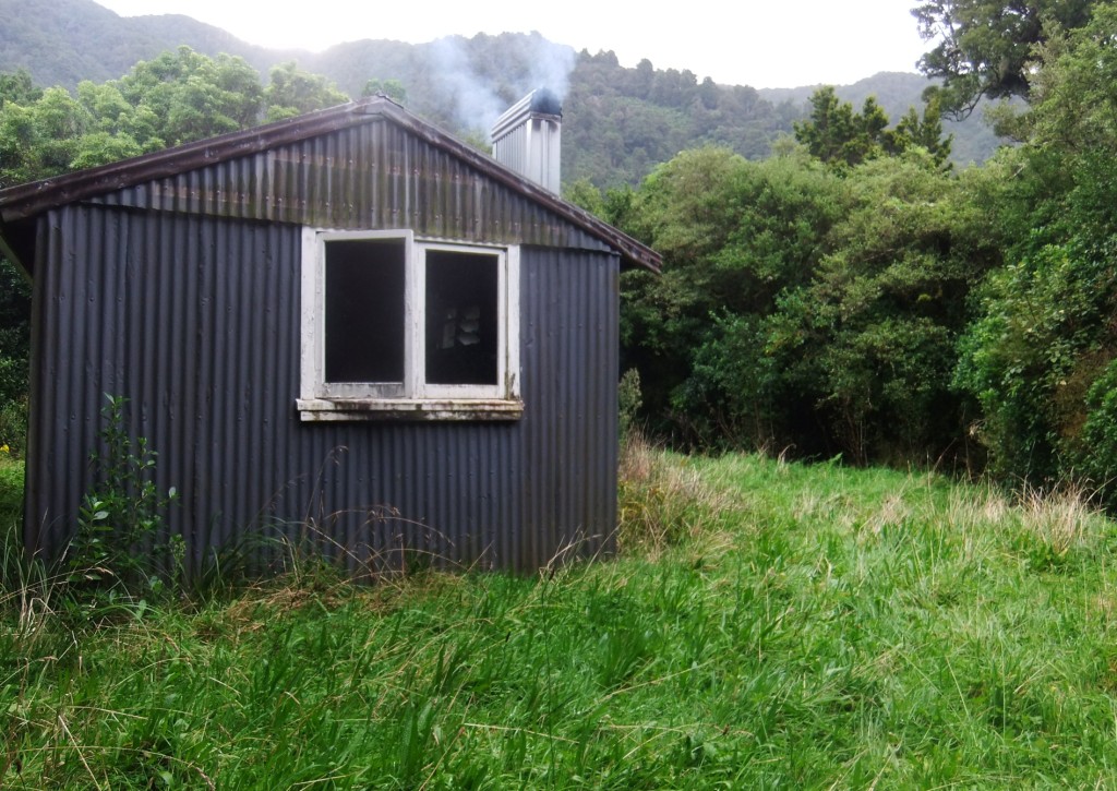
Sayers hut.
There’s no point in roughing it until you have to, so Saturday morning breakfast was not cold muesli with reconstituted milk, but salmon on sourdough and espresso from the French patisserie in Greytown. I couldn’t resist slipping a tuna mayo roll from there into my pocket too.
Mangatarere Roadend is a place less travelled. It’s at the end of a long, winding road that goes to gravel pretty quickly, narrows to one lane wide with lots of blind corners. Previously, there was a concrete ford that had been half washed away. We saw that the council had indeed solved the problem – they had put up a big sign saying ‘End of Council Maintained Road’ just before it. Someone had built up the broken concrete bits with gravel so it was navigable. However, when we reached the roadend we dubiously eyed the pouring rain and decided discretion was the better part of finding a raging torrent that we couldn’t get our cars back through on the Sunday. So back we went and left our cars safe and sound on the other side of the ford. It was only a short walk back anyway.
We headed off in steady rain that didn’t dampen our spirits. It was still warm and calm. After a short piece of indecision about which way to go – you stay on your side of the river, not crossing a rickety bridge to Mangatarere lodge – we were soon ascending the slippery, muddy ridge that would bring us to the unnamed knoll.
We rapidly formed two groups – Logan, Marloes and Ryan forming the advance party and Régine and I bringing up the rear. While the Sayer Track is a short walk at 3-5 hours, it’s a bit of a surprise for trampers accustomed to easy tracks. Roots, mud and treefall, not to mention that for almost all of that time you’re grunting up to the unnamed 771m knoll and then torturing your knees on the descent, make it a challenging few “easy” hours.
As the last party had warned us, there was plenty of big trees down over the track to climb around and over. Someone had been through with a chainsaw though, and cleared the worst of it, but not all of it.
The rain didn’t abate but neither did the warm and still conditions so it was certainly not unpleasant to walk in. Forest ranged from mighty towering beech forest to lower shrubby bush to beautiful goblin forest. The misty rain gave it an ethereal quality where you could imagine dryads and pixies just out of sight, laughing and giggling at these unlikely interlopers in their midst.
Soon we were on the top ridge and passing ‘771m knoll’, unnamed and unmarked. The DOC person assigned the job of track marking had celebrated this peak in their own way by putting up a plethora of orange markers but otherwise it was unremarkable.
Then it was down and down, interminably down. Knees begged the hut to be near. The whole walk was in beautiful forest but with only a few chances to peek out at tree clad and mist framed peaks and valleys. But eventually and abruptly we met Sayer Creek and the Waiohine River flat. A short skip down the blissfully flat track led to a peek of corrugated iron and a rustic old hut in a clearing. The rain had eased during our descent, and we reached the hut in clear weather.
Hut interior.
What a wonderful hut! Though fixed and added to and changed over the decades, this hut has the same structure as it did when built at the turn of the 20th century. Rough sawn and hand shaped wood and logs abounded, and a range of road signs and farm business advertisements showed that cheeky thieves have been with us forever.
Ryan, Logan, Marloes were already there and waiting for us with a blazing fire that Logan tended to all night. It was only mid afternoon so we went exploring. The Waiohine River was well up, with strong flow and whitecaps in the main channel, and crossing it wasn’t an option. No chance to explore Totara Flats or anything like that (it could be possible to bush-bash up our side of the river to the Totara Flats footbridge, but we didn’t try that). There was a big grassy area near the hut that would be perfect for camping, and plenty of fire sites attested to people doing just that.
The next day, we foraged for firewood to more than replace the substantial pile we’d burned through over yesterday afternoon. We cleaned up, and then set off as the same two parties that we’d formed on the way in. There was only one way out – the same way we went in, and over the same 771m knoll. I built a cairn at the top from what rocks and branches I could find – it seemed to need more than just a few orange triangles to mark the achievement of summiting it. The rain had returned, along with a chill breeze – the top of the knoll was the first and only time I felt a little cold.
The descent was muddy and slippery but went quickly. Again, all of a sudden we were at the Mangaterere Stream that signalled the end of our descent and the short flat walk back out to the car.
The ford we were nervous about was indeed up and fast flowing, probably still passable but I was glad I didn’t have to try.
We quickly changed into (mostly) dry clothes and piled into the mostly dry car. Engine on and heater on full – we headed to the Greytown cafe where the cafe owner took pity on us and gave us our very own heater. Soup and wedges got us warm and comfortable and ready for the drive home.