Firstly, for those who know me, let me state that this trip actually started and was completed on Plan A! Yes, I managed to actually lead a trip that not only went someplace but was successfully completed on the intended plan and I didn’t lose any punters along the way. You can check with my punters, it’s true!
Plan A: Go to the luxurious club lodge at Whakapapa on Friday night. Have the Easy trip drop us off at Whakapapa Village on Saturday morning. Walk to Ngauruhoe via the Tama Lakes track. Climb up the snow on the south face. Walk around the crater at the summit and descend on the north face. Then complete the trip by walking out on the Tongariro Crossing track to Mangatipopo. Get picked up and chauffeured back to the lodge for Saturday. Hope for bad weather on Sunday so, we could sleep in. Go to bed, assume bad weather and sleep in regardless. Climb in van and go back to Wellington.
When I suggested this route to Spencer, my fearless co-leader, he said it sounded great but I better make sure that someone had actually been up (or down) the south face. Sure Ngauruhoe looks totally smooth and concentric on the Topo50 but, it doesn’t hurt to ask. I checked with Sharron, DJ and Tony G who have done all the cool stuff and the response was yes, it is possible to go up the south face. I bit more “interesting” with it being a bit rougher with more rocks and small bluffs but still simple climbing. I was given a detailed route description to the base of Ngauruhoe by Tony G and we were off and running- well walking actually, but you know what I mean.
The Trip
After a lovely night in the lodge and some crazy breakfast clean up/lunch preparation we headed out at a civilized hour to our drop off spot at the start of the Tama Lakes track. Megan and I commented to each, for the first time but certainly not the last, that Ngauruhoe was looking really tall and steep from such a distance. Surely it would look much more mellow once we got closer!
 We ambled along with our wee packs loaded down with ice axes, crampons and helmets through nice bush and open moonscapes to Lower Tama Lakes. We had a quick morning tea (Stijn thought we should take a nap- it was a pretty nice spot in the sunshine but we weren’t to be distracted from the mission) and then continued on up the ridge to the view point over Upper Tama Lakes. We reached this point by mid-morning and Stijn decided that the wee rock shelter up there was also a good place for a nap! We convinced him that we should carry on just in case conditions for the climb were difficult and took more time than we thought.
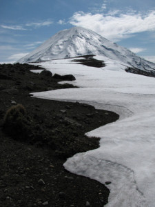
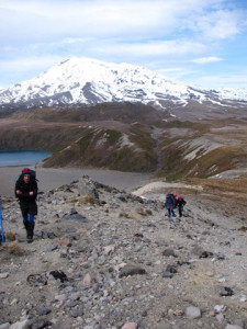
Ngauruhoe was shining in the sun up ahead and Megan and I may again have mentioned that it still looked really tall and really steep. Surely, once we got closer, it was going to look easy – a wee little climb! We headed up the ridge to the west of Upper Tama Lake to 1650. Well, Tony went to 1650, the rest of us were lazy and sidled along on the scree slope just below. We were starting to get into small patches of snow but it was soft enough that we were ok without crampons. Following this ridge and 1650 we dropped back down to a saddle and the base of Ngauruhoe.
There was yet another exchange of wow, it looks steep and tall. Then a sensible discussion on what ridge looked best? Or perhaps the basin in between? We decided to go up to a ridge on our left and follow that until we could determine the snow conditions. We climbed perhaps 30m until we were onto continuous snow and we stopped to don our crampons, loose the ice axes from our packs and put on our helmets. There was discussion about the helmets and Spencer rightly pointed out “Well, it’s your head.” This turned out to be a good decision!
 The snow conditions were really good for cramponing, firm but rarely icy, and we made good progress as we started the days climb in earnest. The ridge proved good and the basin looked like it got steep at the top so, our navigators had made a good call. The gradient was just steep enough that going straight up was too hard on the calves but zig zagging back and forth was hard on the ankles. But these are the things you put up with when summit bagging! So, we climbed up… and up… and up. We stopped to “regroup” a few times (Stijn was probably asking for more naps but I was too busy catching my breath to listen) and managed a couple of photo/jelly bean stops. The skies were a bit overcast but we were still treated to some beautiful views back toward Ruapehu. I kept seeing those windswept looking lenticular clouds and was secretly worried about wind once we got to the top but the wind was light where we sheltered on the South face.
We were perhaps half way up when suddenly there was ice raining down on us from above. Was it the wind? Was it the Ngauruhoe ghost trying to prevent us from completing Plan A? We very quickly beat it into the basin on our left but not before Megan and Kate both got hit in the helmet with chunks of ice. Drama! We all got across the basin safely though and headed to the ridge on the left while still trying to gain elevation in the basin. Unfortunately we were very near the top of the basin where it was steep, as predicted, and there was a small rock bluff. I think this section of the climb was our most difficult of the day as it was a bit crusty, steep and I was a bit stressed after the ice to the head incident. However, we got across to the ridge below the small bluff and carried on up the ridge. I dared to look up at this point to take stock and was amazed to see that yes, we still had a long way to go!
Never the less, we carried on. The snow conditions continued to be good and the winds were still quite light. The total climb took approximately 3 hours and we were treated to a nice flat saddle to have a rest. There was some debate at this point about how best to get up and around the crater. We decided to head straight up from the saddle and then follow the lip of the crater around on the west side to where we could find a good stop to drop off down the north face.
The views of the summit crater were fantastic and otherworldly! Unfortunately there was enough wind to make it pretty cold and us a bit unsteady on our feet (ok we were a bit tired, but it was windy!) so, we snapped a couple pics and made our way around the rim.
Once around to the north side we looked down and debated the best place to start our descent. I have to admit that I was looking at all of it thinking there’s no way I’m going down any of that! So much for it not being so steep up close… Tony finally just started going for it sidling across at a likely spot. The snow was soft and wet so I and the rest of the crew just started loping down behind him. Like lemmings?! That was fun enough but it wasn’t long until the possibility of a bum slide was mentioned. It didn’t take much to convince us! Tony and Stijn continued down like civilized trampers while Megan, Ian Spencer and I stopped to don the proper bum slide kit.
Tony and Stijn couldn’t figure out why the heck we had stopped for a picnic 500m up. What in the world were we doing up there? Surely it was some silly pfaffing again? They were soon to see that they were missing out on the fun!
So, yes I am Canadian but, this was my first major bum slide experience! Canadians carry toboggans and careen down mountains with dignity. Little did I know what I have been missing out on!
I learned a few things about bum sliding: Definitely wear over-trousers (you get wet and don’t go fast enough without them), definitely tuck your jacket in to the over-trousers (you end up with snow packed in places you really don’t want it otherwise), use your ice axe as a brake/steering rudder, and Spencer felt the need to mention that one should “Never, Never, Get Out of Control!!” Clearly there were too many rules ‘cause I managed to forget that last one… I may have been air borne a couple of times…
Following recounting the bum slide experience and a wee snack (did Stijn finally get his nap?) we headed toward Mangatepopo down the Devil’s Staircase and the Tongariro Crossing track to be picked up at the car park.
This turned out to be an awesome trip. The snow was in great condition compared to the soft north side and it creates a great loop for us trampers who don’t like to retrace our steps.
