
As we climbed up to Mt Matthews’ South Saddle, I found myself thinking of Aesop’s fable The Hare and the Tortoise. ‘Slow and steady; slow and steady’. I did my best to keep an even—but what seemed like sedate—pace. It was a change to how I would normally climb a hill with just a day pack. I knew I could go faster and get to the top quickly. However Tony did well to reassure his two sidekicks that a slow and steady pace on ascents on a long day would see us last, and result in something left in the tank at the end of it.
Tony (leader), Toby and I left the Catchpool carpark under the cover of darkness and returned under the cover of darkness. In between was a day of activity to increase the fitness levels. For Toby, it was training for an upcoming Mont Blanc climb and for Heather, alpine trips this coming winter.
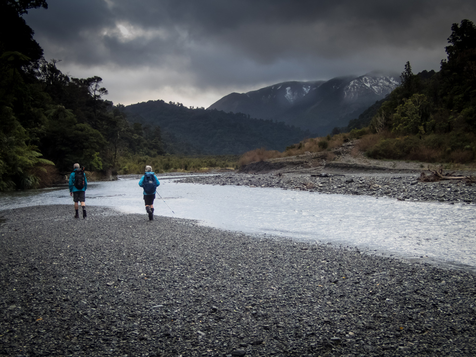
We started along the Orongorongo Track at 0700 hrs. The weather left a lot to be desired—it was overcast and raining. Tony imparted good advice around the need for flexibility and acceptance that plans sometimes have to change. Following some collaborative discussion when we got to the river, we decided we would abandon Plan A which was to head up to Tapokopoko, down the Tapokopoko Stream, up to Mt Matthews and back down to the Orongorongo River. Instead we would take Plan B a more direct route to Mt Matthews before returning via the Orongorongo River. So up river we went, in the rain.
The track junction for Mt Matthews is well marked with giant-sized orange triangles in the centre of Mt Matthews Stream. Shortly after entering the wide mouth, we veered off to the right and entered the bush to make our way up. Slow and steady; slow and steady. We soldiered up the spur—at one point under a bombardment of hail. Given the hail and the cold southerly gusts that increased as we gained elevation, we made a further change to our itinerary—Plan C. Instead, we would stay low and head down the Mukamuka Stream to the coast rather than continue on up to Mt Matthews and its North Saddle.
As we traversed across the hillside to the South Saddle, I for one was hoping for some remnants of the previous day’s snow to be waiting for us. Unfortunately, any snow that had fallen during the last 36 hours had melted away. However, reasonable views to the north, down to the Orongorongo Valley, and to the southern coastline, were there for us to enjoy despite the dismal sky.
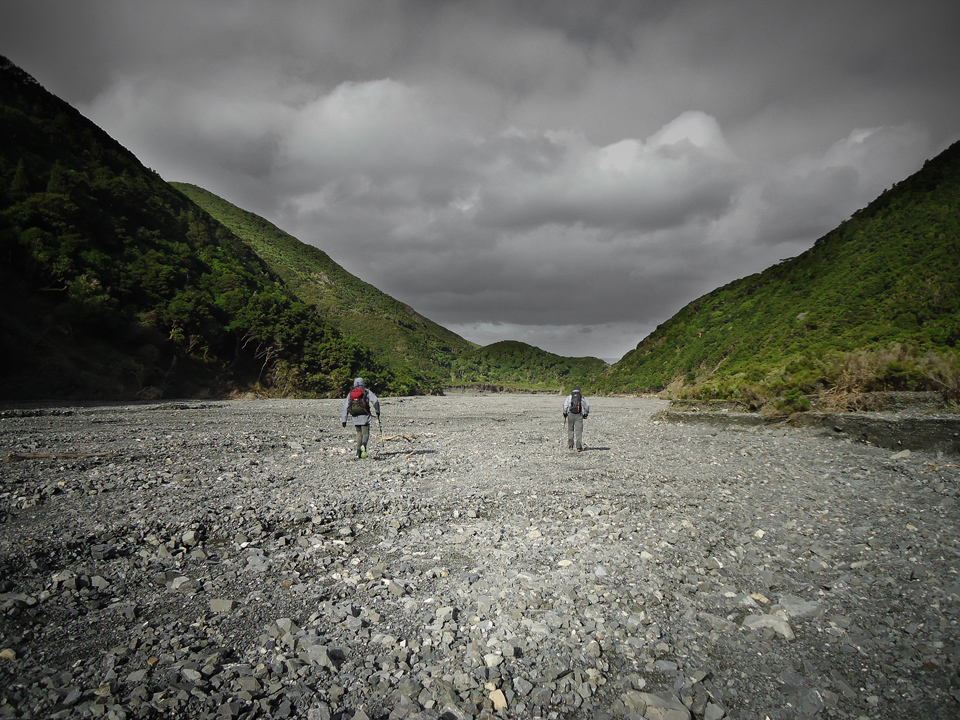
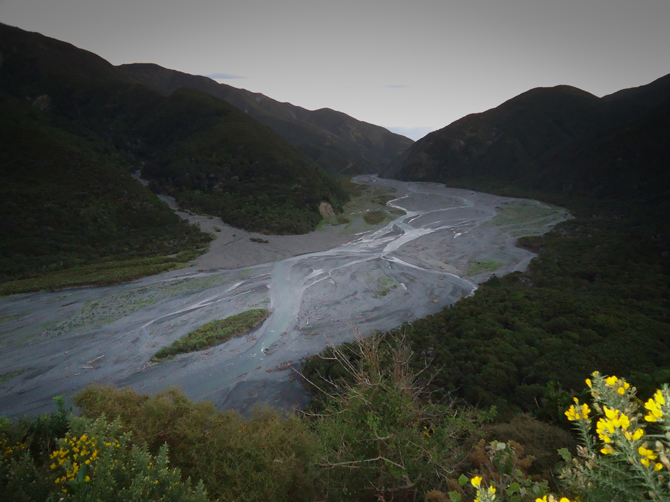
We soon found ourselves in more sheltered conditions once we started our descent down the headwaters of the Mukamuka Stream. (The contrast of the width of the river’s headwaters to what we were going to be walking down a couple of hours later was quite pronounced.) A trip down the Mukamuka is well worth it. The upper reaches are easy to climb down with plenty of vegetation to help when needed. The erosion as the valley starts to widen is varied and somewhat different from other rivers. On one bend was what appeared to be a vertical stratum line. Deadfall was minimal. But there was a lot of fording until we reached where the river widened at the junction of the Tapokopoko, Mukamuka and Hinakitaka Streams.
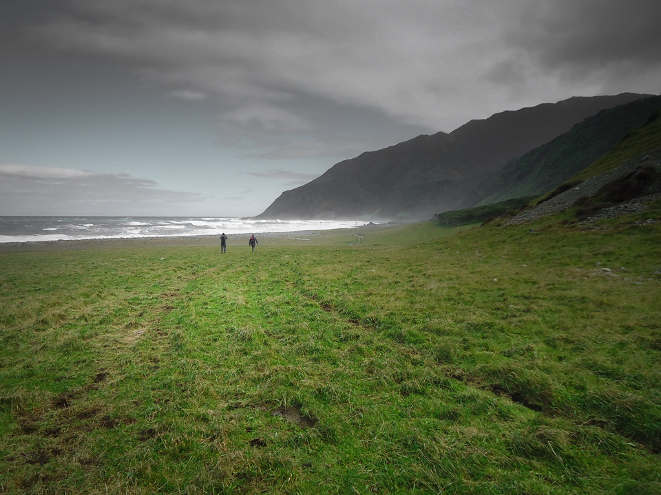
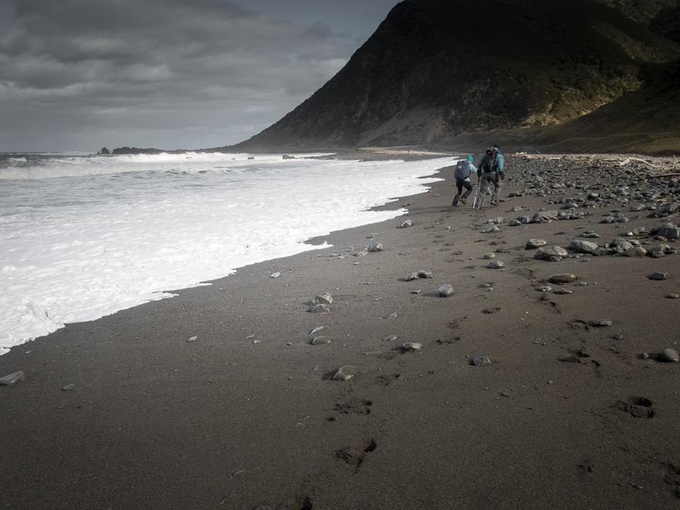
Rough seas in the form of impressive large roller waves and a strong southerly greeted us when we reached the coast. From there we made our way south to Windy Point, along to Fisherman’s Rock (where we enjoyed a second lunch break) before heading further along the coastline to Turakirae Point. The coastline track is an easy walk sandwiched between farmland on the lower slopes of some big hills and tumultuous waves.
We reached the mouth of the Orongorongo River shortly before 1600 hrs with another 10 kms of walking back to Catchpool carpark ahead of us. However, Tony suggested a bit of Nav practice and a more attractive route than the Coast Road could be in order. We could head up the Orongorongo River, up over Cattle Ridge with a final drop back down to Catchpool. Toby and I were up for it. So back into water we went (the boots and socks were still wet from the Mukamuka).
Part way up the Orongorongo River Tony offered some unplanned river-crossing instruction. Given some sections had a current faster than a swift walking pace, and the water being unclear and me not that much taller than Bilbo Baggins, I very much welcomed the offer. The three of us linked up and crossed the river at three or four of the deeper channels. What a difference it was crossing as a group (albeit only three of us) than what it would have been for me on my own.
We continued up the river until we reached the spur on the true right up to spot height 376. We located the bottom of Matai Stream and the 4wd Baker Track up the spur. After more climbing—slow and steady; slow and steady—and with head torches now on, we reached the Mt Baker pine forest. We made our way through the forest, consulting the compass once and the map twice, until we reached the point where the pines adjoin Cattle Ridge track.
As if we had not had enough walking for one day we took a short detour to the Baker lookout. The night sky was impressive. We spied a satellite as it passed through the Southern Cross and marveled at the Milky Way. But as many good things come to an end, it was soon time to head back down to civilization. So via the Butcher Track we returned to the Catchpool carpark 13 hours after we had left it that morning.
Did Toby and I find the slow and steady pace on the ascents help with endurance for the day? We certainly thought so even though we had clocked up 44 kms on our feet. Despite being ready for a sit down once back at the carpark, we could have walked further had Tony not have been able to wave open the gate barrier at the park entrance. (Thanks to Richard for that part of the day’s logistics.)
It was good day out for three keen trampers wanting to add to their fitness. As a day trip, it made the purpose of the training particularly effective given we were able to carry just day packs. Thanks to Tony for leading and Megan for organizing the two groups for the first Alpine fitness training day of the season.
PS by Tony G.
The comments to this story discuss access from the Baker Track to the Butcher.
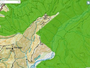
Below is topo map of the area concerned with the Remutaka Forest park boundaries overlain. So the track up the spur from the Orongorongo River to point 376 is on the boundary and all OK. The 4WD Baker Track north is likely to be on the boundary (making allowance for misalignment of the map layers) until you reach the pine forest (where the track is shown emerging from the small piece of forest park is also OK. But from here you need to follow the eastern-most edge of the pine forest north east and continue to the furthest pointy bit north where the pine forest touches the Cattle Ridge Track.
If you do that (or the equivalent in reverse) you should be entirely within the Remutaka forest Park and won’t encroach on any private property.
A couple of months after that big day out with Tony (2017 winter), I returned to the river and the 4WD Baker Track. The bottom of the track up the spur to 376 was tricky to find. We didn’t find it and the weather was no fun for bush bashing. But the top of the track wasn’t hard to find. (Not that I would recommend first timers starting from the top.)
While heading up the 4WD road we also met a nice friendly fella driving down. He stopped. We chatted. I asked who owned the land. He replied “I do”. We were just north of 376. We continued NE (as Tony advises) to the furthest pointy bit. I took a waypoint on my GPS when we reached the Cattle Ridge track -41° 21.448′ 174° 56.383′ (helpful for the reverse route). Typing this into Google Maps and using satellite view, shows the northern furthest pointy bit, where the pines join up with the track, nicely.
I did a day trip with Glynne Lloyd years ago up the Baker Track out of Matai Stream, through the pine forest, and down to the Catchpool, and we ran into the landowner who lives in the house on top of Mt Baker and he was a nice friendly helpful guy who was quite happy for genuine trampers to go through his land. So while you should obviously try to ask permission in advance if you can, in practice I think you are unlikely to find yourself being shot at (assuming it’s still the same landowner).
Geriatric old codgers will of course remember when the pine plantation up there didn’t exist, it was all open pasture land with superb views, and the Trampers Marathon used to go through there.
The last time I looked at the track up the spur from the river it was completely overgrown and unidentifiable, so it’s interesting to learn that it has been recut.
Yes – agree with your description of a route that remains within the park boundaries. I’ve added a PS to Heather’s story that may be helpful. Now you should be confident enough to complete a full circumnavigation.
Your circuit from the Catchpool is actually the course where the Wellington Associated Mountain Clubs for many years ran the tramper’s marathon. Open to all club members you had to be wearing tramping boots to compete – winning times were usually about 1 hour 20 minutes for the circuit.
That’s a very good question. There seems to be a jumble of private land, reserve of some sort and Forest Park in that area. In theory we were probably on private land in the forest and actually should have asked for permission before even walking up the Orongorongo River from the coast. But it was a quick decision very late in the day – we had to get back to our car somehow and all the other transport had left.
Clearly the 4WD Baker Track is mostly outside the park – and I’m unsure if the old track directly up the spur from the Orongorongo River to point 376 is still passible. A few years ago it was badly overgrown but there were rumours it was recut.
If you walk up the Butcher Track from the Catchpool to the turn off to the lookout and carry on along the Cattle Ridge Track for about 10 minutes on your right is a fence post at the sharp corner boundary of the pine forest. You can then follow the fence line along to meet with the Baker Track. Then you can follow the 4WD track to 376 – and if the old walking track down the spur still exists drop down to the Orongorongo – and all within the park boundary. Otherwise if you know your plans suggest you seek permission – better than a warning shot.
Thanks. Yep, I can appreciate “late day decisions”.
I take it that sticking strictly to the route you described “You can then follow the fence line along to meet with the Baker Track. Then you can follow the 4WD track to 376 – and if the old walking track down the spur still exists drop down to the Orongorongo – and all within the park boundary” is fine to walk – outside of this, seek permission. Please please correct me if I’m wrong.
To provide some useful information back to you (and to others). The old track up the spur from the Orongaronga River is still passable. I walked it from the river up to 376 in the weekend, before chickening out once I hit baker track (thinking I was out of bounds), I then dropped back down to the river and walked back to catchpool from there. A long day.
It is very steep, marked, cut – as well as you could expect – and requires all limbs to action to get up the bottom 1/4 section of it.
Is it ok to cut from Butcher to Cattle Ridge to Baker Track through the pines before dropping down from 376 into Orongaronga River? I’d like to do the walk but a little bit paranoid about private property and DOC land shading. The maps and their shading have got me totally confused. Any help would be really appreciated, thanks 🙂