
 I’ve always wondered about that lonely meandering track from the Orongorongo valley, that finishes in the unfashionable backwaters of the South-West Wairarapa. And I see that Kate Cushing must feel that way too, since she’s leading a trip here on 29 June. Two of us took a look last month on the spur of the moment and it is well worth it. Here’s a sneak preview of why you should sign up for this trip.
Weather
Cloud at about 800m with light South-Easterlies both days. Scattered showers predicted but none eventuating.
Access
See “Driving Instructions” below.
The trip starts as a Friday morning inkling. The forecast is settled and at least one of us has always intended, but never quite got around to knocking off this Rimutaka Range crossing.
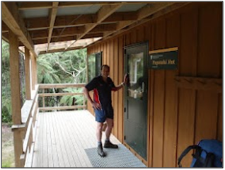
We leave Catchpool at 10am on Saturday and it is easy going over the Orongorongo track and up the river to Papatahi Hut (about 3hrs). The hut is new and in fantastic condition but locked with bookings essential (link below).
From here, you need some map reading skills. About a kilometre upstream from the hut the track heads up North Boulder creek then into the first tributary (true left) before launching itself up a steep 500m ridge climb (some kindly soul has left a rope in one particularly gruesome spot). It eases for the last 100m before topping out at just over 900m.
The view expands as we climb until, just as we identify the Makara wind farm, we ascend into mist. The mossy condition of the forest shows that the clouds scrape along these hills a fair proportion of the time. We reach a small clearing with a survey pin at the top about 3pm and just manage to send a text to our driver. We’re in cloud and it’s a bit chilly so we don’t stick around. The track drops gently to about 700m then plummets to 300m, before easing us down to 200m. The descent is fairly tricky in places; the track is not always easy to find and it’s loose or slippery underfoot.
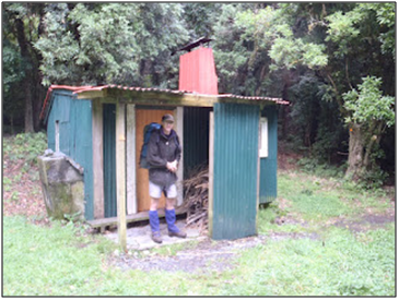
Wharepapa hut is on the other side of Wharepapa stream (true left) but sign posted: “Joe’s Hut.” At 5pm it’s already quite dim and we light candles as soon as the door shuts. The hut is well looked after and the log book indicates relatively light use with a lot of hunters.
The next morning we follow the track from the door of the hut (not quite what the map shows) about 140m up to a saddle which drops us into the Battery Stream catchment. The track from here is fairly rough in places and easily lost but we don’t have too much trouble working our way out into gently shelving beech forest which fades away for a last 2km walk along a farm drainage ditch to the road; about 3hrs after leaving the hut.
All up it took us about 10 hours; we aren’t super fit and weren’t pushing it, but I suspect a bigger party will be slower. Track conditions are variable and a little challenging in places. I thoroughly enjoyed this impromptu trip; tested some new gear and didn’t waste the weekend mowing the lawns; definitely one for the bucket list.
Useful Information
Map
http://www.topomap.co.nz/NZTopoMap?v=2&ll=-41.325185,175.076016&z=15&pin=1&lbl=Wharepapa%20Hut
DoC track description
http://www.doc.govt.nz/parks-and-recreation/tracks-and-walks/wellington-kapiti/wellington/papatahi-crossing/
Papatahi Hut
http://homepages.ihug.co.nz/~fiski/nzhuts/nzhuts5.html
Wharepapa Hut
http://www.doc.govt.nz/parks-and-recreation/places-to-stay/backcountry-huts-by-region/wairarapa/wairarapa/wharepapa-hut/
Driving instructions
West end: Catchpool stream off the Coast Road from Wainuiomata.
East end: From Featherston, turn South onto the Western Lake Road (also the way to Cross Creek). Follow this for ages until you leave the lake behind and see the “East West Access Road” coming in from your left. About 2.5Km past this there is a barely visible pull off on the right with a faded DoC sign. There is a farm entrance labelled “Devon” about 200m earlier. If you go around a sharpish right bend and a bridge you have gone 500m too far.
Cellphone coverage
Mostly none. Some patchy cover at the top of Papatahi; intermittent coming down to the farm land and at Western Lake Road. I wouldn’t rely on it.